
Introduction:
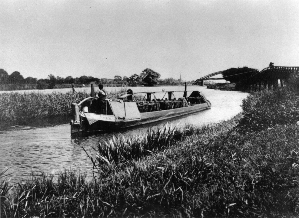
Long Horse Bridge, Derwentmouth carried the towpath at the junction
of the Trent and Mersey Canal (from the potteries and NW) and the Trent
Navigation downstream (to Trent Lock - junction with the Grand Union route
to London - then to Nottingham and NE). It carried the path across
the upstream arm of the River Trent, which is navigable to Cavendish Bridge,
Shardlow.
The bridge was therefore a key feature at one end of James Brindley's
Grand Trunk canal as it enabled boats to be towed from the canal onwards
down the River Trent. Originally a wooden bridge, the last reconstruction
was a concrete bridge erected by the Trent Navigation Company in 1932.
para added 27 Aug 2006
As early as 26 Sept 2000 BW and DCC had discussions about a replacement
bridge, but there was no indication to the public or BW user groups of
BW's intent at this time. (see timeline)
In Nov 2002, a report prepared for North West Leicestershire District Council by Sustrans includes 'Long Horse Bridge .... Fundraising is in hand for a new structure that is planned to serve cyclists and horses as well as walkers. The project partnership includes British Waterways, several Local Authorities and the British Horse Societey.' This does not appear to have resulted in any dialogue between BW and User Groups (the BW process for consultation).
The bridge was demolished by British Waterways in 2003 because there was some local spalling of the concrete revealing the steel reinforcing and BW decided that it was uneconomic to repair. At that time there was an attempt to get the bridge spot listed which involved some discussion with BW.
A replacement bridge was promised, but in June 2003 it was announced that there would be a delay because Derbyshire County Council would like a wider bridleway style bridge for which funding had to be obtained. This was to fill the missing link between the Mid Shires Way, from the Ridgeway in Buckinghamshire - which currently finishes at Warren Lane near Sawley Marina - and the Derwent Valley Heritage Way which according to web page nationalheritagecorridor.org.uk, follows the T & M towpath from Derwentmouth to Shardlow and then the old A6 through the village to Ambaston Lane and the Derwent. (This path was previosly signposted to leave the T & M at Derwentmouth lock by walking across the lock gates, then following the Derwent - presumably still an option for walkers) Neither of these routes is currently suitable as a multi user track, the towpath being narrow and uneven, with low arch bridges. How would a bridleway reach the A6 from the towpath at Derwentmouth? Where would it join the A6? The towpath along the Trent from Sawley to Derwentmouth is also narrow and uneven, and has some more narrow bridged sections. There has been no consultation* with BW User Groups or Shardlow Parish over potential changes to these paths to accomodate the multi user path, other than a proposal as part of a gravel extraction plan between Derwentmouth and Shardlow village which is being strongly resisted.
*update 24 Nov 2006
On 14 Nov 2006, DCC (John Holmes) presented information about the
proposed path routes to Shardlow Parish Council - see entry in timeline
section below
In February 2005 British Waterways may have announced at a User Group meeting that the bridge would be relocated, but there was no discussion over the details - they has previously stated Sept 2004 that DCC would be the point of contact for all future works.
DCC made the detailed plans available in June 2005, and despite some objections the plans were approved without further debate. However, the decision notice pointed out that the decision only related to planning controls, and that other aspects should be addressed to the appropriate authority. So British Waterways had effectively avoided any debate over Waterways Heritage and Waterways User Opinion relating to the proposal.
The project has been delayed through 2006 due to land acquisition difficulties (which would not arise if the bridge was built at the original location).
next para added 26 Aug 2006
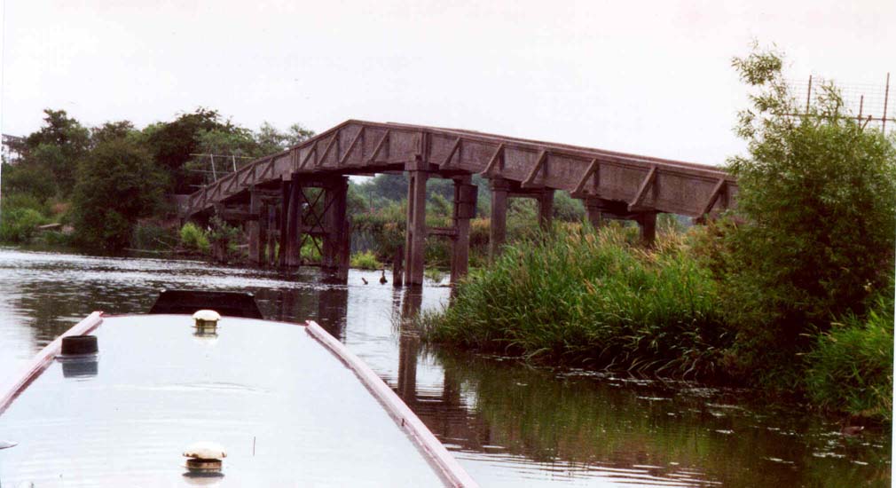
The plans show the bridge relocated 140m upstream on the branch
of the Trent Navigation that terminates at Cavendish Bridge near Shardlow.
The relocation and bowstring bridge design each make it impossible to tow
boats from the bridge which was the purpose of the original structure,
and which was still an important safety feature in the event of a boat
breaking down. Additionally the proposed bridge has a 3.9m walkway compared
to the previous 1.4m, which many fear will invite unauthorised use by vehicles.
The proposed routes of multiuser paths to either end of the bridge have
still not been discussed* with the local population and parish council.
The published plan shows the ramps leading from the bridge being 2.2m track
width ( 3.3m between fences) and the continuing paths being only 1.2m wide.
*update 24 Nov 2006
On 14 Nov 2006, DCC (John Holmes) presented information about the
proposed path routes to Shardlow Parish Council - see entry in timeline
section below
There are very strong objections to the plan from the public and from boaters. People do not want a radical change to be made at this important heritage site. From the boaters point of view, the facility to manually haul a boat from the river to the canal in the event of breakdown would be lost. There has been no public consultation (see * above) over the routing, design and planned useage of the connecting paths that are the justification for increasing the bridge width.
next para added 26 Aug 2006
The reason given to resite the bridge is cost, the river being much
narrower 140m upstream; but money is apparently being wasted on an expensive
single span bridge design of excessive width, and compulsory puchase of
land for the new location. BW demolished the previous bridge on the grounds
that it was uneconomical to repair. Surely they should be required to provide
a like for like replacement as originally promised, and if DCC desire a
wider bridge then they should fund the difference (or build a separate
bridge upstream) without compromising the BW commitment to protecting waterways
heritage and BW's accountability to local commuities. (see quotations
from BW policy statements under supporting documents section) Why
have we not been offered an appraisal of optional solutions as is taking
place for the proposed foot and cycle bridge at Matlock? (see web
page derbyshiredales.gov.uk - view local strategic patnership then select
Matlock Masterplan then select footbridge feasibility study and drawings)
In view of the delay to the project, the opportunity has been taken to try and have the project reassessed, with some meaningful consultation - but BW and DCC appear reluctant to do so.
A possible influence on the bridge plans is a proposed gravel extraction site which was put in the Derbyshire mineral plan without any prior consultation. This is between Derwentmouth and the Shardlow flood protection bank, on the towpath side of the canal. Part of the scheme involved taking the gravel across the Trent by barge between the original bridge location and the proposed bridge location. The gravel proposal had not been approved and is being vigourously opposed - but has it had an influence on the bridge design and location? If the relocated bridge and gravel schemes go ahead, how would the gravel be loaded onto barges across the new path? Or is it intended to put a gravel conveyor on the new bridge?
This web site is intended to provide information to the public, and objectors to the current proposals are urged to write now to the addresses at the bottom of the page. The authorities seem to think that there are few objectors to the relocation of Long Horse Bridge, which is not the impression I get from locals and boaters. So PLEASE WRITE!
FOR UPDATES AFTER Nov 2006, please see Timeline below
John Cooke, Shardlow resident and boater
- British Waterways building and maintaining a 2.0m wide bridge. It
would cost
£780k plus regular maintenance costs;
- British Waterways building and maintaining a new wider bridge, with
a
contribution from the County Council. This was judged unacceptable
as the
County Council would only fund widening the bridge to 2.7m, whereas
British
Waterways believed that a 3.9m bridge would be needed to segregate
pedestrians and horses for safety;
- British Waterways transferring responsibility for the bridge to the
County
Council, and making a payment to them to represent their obligation
to rebuild
and maintain a footbridge. This option was recommended, and would involved
British Waterways paying £510k. If British Waterways could guarantee
that their
payment would be made in April 2005, the County Council would accept
liability
for reconstructing the bridge.
23 Sept 2004 (ex BW website) - BW Board
Meeting lists under Operational Projects (BWB3149):
The following projects were approved:
including:-
Disposal of Long Horse Bridge, River Trent - £515k
30 Sept 2004 BW user group meeting
minutes:
'Derbyshire County Council will be taking over responsibility for Long
Horse Bridge and will therefore be the point of contact for all future
works. [BW] will ask the council to inform the users of the planned
design.
Undated but appears to be during this period(not
made public until July 2006 Ombudsmans report)
The operations manager prepared a further report. This said that the
original scheme could not go ahead because the County Council had not obtained
some of the grant funding upon which they had been relying. The options
had been reviewed and an alternative crossing, 140m south of the existing
site was feasible. The significantly reduced span would allow a bridleway
bridge to be constructed within the available funding. The County Council
had agreed to the principle of a relocated bridge, but were now unwilling
to project manage it or take the construction risk. The net cost to British
Waterways would be £601k, after a funding contribution from the County
Council was taken into account. [see Timeline 13 Dec 2006 re Feasibility
Report]
24 Feb 2005 User Group Meeting advised
that the bridge would be relocated. There was no offer to debate according
to user reps, and the information provided was minimal. The plan was fixed,
and would go through the DCC planning process.
4 April 2005 The notes of the 24 Feb meeting
state:
‘....-agreement has now been reached with Derbyshire County Council.
British Waterways are designing and building the bridge which will then
be taken over by the County who are part-funding the project. It is proposed
to be a 50m span bowstring truss steel bridge, approximately 140m upstream
of the old location. Derbyshire are leading on the planning permission
and will arrange for the necessary footpath diversion. It should be on
site in July 2005 and completed by Christmas. The bridge will be able to
accommodate the future bridleway aspired by the county council' [NB
the notes of user group meetings are not minutes and may contain information
that was not declared at the meeting]
June 2005 detailed plans of the proposed
bridge are made available for the first time at Council Offices and shown
at Shardlow Village Hall on 21 June. Ref CD9/0505/23 There are some letters
of objection sent to DCC.
1 Aug 2005 DCC letter to objectors that
plans were approved, noting that the permission relates to planning control
only and that any other statutory consent necessary must be obtained from
the appropriate authority.
There are many conditions attached such as: including the building
and subseqent removal of a site access road (not exceeding 3.5m wide) from
Wilne Lane, Shardlow to the site. Before development is commenced, a scheme
for the landscaping of the site and fencing associated with the approach
path to the bridge shall be submitted to and approved in writing by the
County Planning Authority. An ecological resurvey is required prior to
commencement to ascertain that no protected species will be adversely affected
eg Otter, Water Vole. Any hedgerow removal shall not take place between
March and July.
9 December 2005 DCC respond to Mark Todd
MP concerning the delay :- 'DCC and our partner, British Waterways are
experiencing some difficulty in receiving instructions from the two Angling
Clubs who are joint landowners on the Leicestershire side of the River
Trent......with regard to land take for the bridge abutment.
.....the land needs to have been secured before the contract can be triggered.
6 Jan 2006 J Cooke writes to Mark Todd
MP referring to the continuing delay and lack of consultation regarding
waterway users, and requesting that the options be reconsidered with some
meaningful consultation.
17 Jan 2006 BW Neil Harvey replies to J
Cooke that to reconstruct at the original 1.3m would be unsafe to include
a bridleway, therefore 2.7m is required and the cost at the original
site would be £1.2M, whereas relocating 140m upstream would almost
halve the span .... and reduce the bridge cost to £870,000
23 Jan 2006 J Cooke to BW Neil Harvey -
re lack of discussion at user group meetings, where was the process that
ensures the plans were considered from a Waterways Heritage and User viewpoint?
Why not erect a direct replacement as promised at the 12 June 2003 user
group meeting? etc
24 Jan 2006 BW Neil Harvey replies that
proposals were presented in detail at user group meetings and BW asked
for comments at the meeting, and that all comments received were positive
acceptance.[these statements are strongly disputed by those user
reps I have spoken to]
25 Jan 2006 J Cooke letter to Waterways
World re continuing delay, lack of consultation, unsuitability of design
for waterway users and heritage viewpoints, so why not revert to a direct
replacement at original location?
9 Feb 2006 (Waterways World advise that)
BW feel that there may be cause for a formal complaint and that to reply
through the medium of WW would not do full justice to the comments.
14 Feb 2006 Stage 1 BW Caroline Killeavy
letter supporting the reply previously given by Neil Harvey.
22 Feb 2006 J Cooke reply to BW Caroline
Killeavy - wish to have the matter reviewed further, including the decision
process leading to the demolition of the previous bridge. Also asked where
the multi user trail is intended to go on the Leicestershire side, as Neil
Harvey's letter 17 Jan suggests that the narrow towpath and resrictions
at Sawley bridge are inadequate for the purpose. [no reply to
these points, just movement to stage2 of complaints process]
16 March 2006 Stage 2 BW MD John Lancaster
letter . 'The bridge it replaces was a 1930's structure of no particular
merit, and there is no case to replicate it.etc The design of the new bridge
intentionally does not replicate the old, and it is not intended for horsedrawn
operation ....... The issue that drives the new siting is funding......
the current proposal saving BW £470k.
18 Mar 2006 J Cooke reply to BW J Lancaster
making the case for a rethink and the desire for some meaningful consultation
before it is too late ... [since Feb 2005, at no time
have BW offered to discuss the proposals or available options] - but
see 21 Sept 2006
next para amended 17 September 2006 re letter resend
2 May 2006 J Cooke letter [text below]
to Cllr Brian Lucas, DCC asking for the plans to be reconsidered, for the
bridge to be at the original location, and questions over the lack of information
and consultation on the proposed paths to the bridge. [still no reply
at 16 Aug, followed up 7 September to find that DCC had not received it
- resent 7 Sept, full reply promised] - see 27 Sept reply below
24 July 2006 Stage 3 following correspondence
and discussion, the Ombudsman's report is issued. It can only address the
issue of whether BW satisfied their own procedure for consultation, and
did not uphold the complaint primarily because the user group notes issued
4 April 2005 should have alerted the user reps. The Ombudsman cannot consider
the location or design of the bridge - these things are outside scope.
24 July 2006 IWA J Baylis letter to BW
Caroline Killeavy complains about lack of information at user group meetings
and requesting full report at next user group meeting Oct 2006
27 July 2006 BW Caroline Killeavy reply
claims project presented at two separate user group meetings, at which
designs were presented. [This simply is not true, and the Ombudsman
report acknowledges that detailed plans were never shown - para 6.2] Offers
to have someone present the current situation at the Oct 2006 user group
meeting.
10 August 2006 J Cooke - following discussion
with J Baylis - letter to BW Caroline Killeavy requesting full review
at Oct user group meeting:
1. a review of what was said or presented at the September 2004 and
February 2005 User Group meetings, in the presence of those who were there
on both sides of the table so that we can clear up the discrepancy of views
referred to in the Ombudsman’s report. This should include bringing the
A3 plan which should help jog people’s memory if necessary. This should
not take long but it would be good to reach a consensus and this should
clear the way for the following.
2. a presentation of the costs to revert to a bridge at the original
site, based on the simplest cost effective design such as a concrete trestle
bridge which might be more in keeping with other historic structures on
the Trent Navigation. There are many examples on the upper Thames of modern
but simple concrete trestle bridges that are similar in appearance to the
earlier wooden bridges. We believe that the current proposed 3.9m width
is hugely excessive, so please indicate costs for the minimum allowable
width noting that there is no reason why people or horses should not wait
if necessary for others to clear the bridge at busy times. As the previous
bridge was 1.4m then I would suggest that the 2.7m desired by DCC would
be ample.
3. a review of the finances for the project – how much and where the
money is now (the BW and DCC contributions), expenditure to date, current
forward commitment and cancellation costs, and how to deal with the increased
costs of compulsory purchase and delayed construction including the latest
cost estimates. The ability to fund a change of plan as above.
4. a debate about where we go from here, noting that there is extreme
dissatisfaction from users and local residents over the current proposals.
Obviously this should include what has to be done to achieve our objective
of having a replacement functional Long Horse Bridge at the original location.
5. if still relevant, a review of the current proposals re design and
location; progress on land ownership and compulsory purchase; the extent
of commitment to hardware; and an update on the timescales. (Please show
the plans as used in the DCC planning consultation process, plus any amendments).
events added 6 Oct 2006
21 Sept 2006 BW Newark had an informal
meeting with 3 Waterway User Group reps and me to explain their plans and
constraints. They showed their plan for the repositioned bridge (as planning
application) and gave costs for the options:
£1,071,000 for a 2 metre wide bridge on original site,
with no contribution from DCC
£1,310,000 for a 3.9metre wide bridge on original site, with
£280k contribution from DCC
£881,000 for a 3.9metre wide bridge on the new site, with £280k
contribution from DCC
Cost to BW therefore £1,071,000 or £1,030,000 or £601,000
BW's position is that there are currently insufficient funds available
to build the bridge on the original site, and it is BW's view that the
heritage and functional issues that drive the campaign for a bridge on
the original site do not justify the transfer of BW funds that are currently
allocated to other projects. They say they can only support the £601k
contribution.
I advised BW that I would continue to campaign for a replacement at
the original site, and persue options and funding with DCC and my MP.
For example, DCC could reasonably be expected to contribute their £280k
to a 2.0 metre wide bridge recognising that this would be to multi user
standard equal to that proposed at Matlock. This would reduce the
shortfall to £190k. It will be some years before the bridleway reaches
the bridge, and if then it is proved that 2.0 metres would not allow horses
to be led over the bridge due to legislation, then there is a viable alternative.
The County Councils could work to upgrade the footpath on the Leicestershire
side between the Long Horse Bridge and Cavendish Bridge to a bridleway,
for pedestrians and horses only.
27 Sept 2006 DCC Councillor Brian Lucas
gave some information on the proposed path routing, but it still remains
unclear and futher information has been requested. He said:
'It is proposed that the links to the new bridge on the Derbyshire
side will comprise the existing towing path of the Trent and Mersey Canal
(footpath only), and a new 4m wide multi-user path immediately south of
and adjacent to the towing path hedge. The provision of this strip of land
was agreed, in principle, by Lafarge over 3 years ago as a precursor to
opening discussions to upgrade the bridge. The path would not involve excavation
into the surface to avoid disturbing any potential archaeology and would
require piping to cross the Cow Way drain in two places. This braided route
would afford socially inclusive access (walkers, cyclists, horse riders,
disabled and less mobile people) to the bridge and Trent Valley, with minimal
disturbance to the environment. The temporary access path for construction
of the new bridge (this is required to build the abutment - the new bridge
can be craned in from the Leicestershire side) may be re-routed to follow
the line of the permanent path and we will look into this possibility.
If there is a viable alternative alignment to this proposed multi-user
link, my Officers will gladly consider it.
On the Leicestershire side the route does not follow the towing path, other than footpath only. The multi-user link will follow the line of footpath L91 south to Tamworth Road.'
My reply:
'On the Derbyshire side, the strip of land agreed by Lafarge would
not reach Wilne Lane as they do not have rights over the last field. Although
the towpath is wide on this last section, it arrives at Wilne Lane on the
approach ramp to the canal bridge, and is blind to traffic coming over
the bridge. The situation is further complicated by the adjacent cottages.
So, what is the intended route for the path from the flood bank crossing
to Wilne Lane?
What is the intended route of the path onwards towards Ambaston?
On the Leicestershire side, the route south to Tamworth Road that you describe would I think involve footpath L91a, which then links to the the A50 island underpasses and paths to Lockington and Hemington. How will the bridleway connect to the Midshires Way towards Kegworth, which currently terminates at Warren Lane (Sawley Marina, Tamworth Road)? I had thought that the route would be parallel to the River Trent towpath, running East to Sawley Bridge although there are difficulties there due to the blind bend on the busy Tamworth Road.
It would be a great help if you could supply a map of these proposed routes.'
See 23 October.
4 October 2006 Shardlow Parish Council discussed
this topic amid concerns over lack of consultation over both the bridge
design and location, and lack of information and consultation over the
path routes. Resolved to persue DCC to arrange a meeting between interested
parties including DCC and BW with a view to obtaining a solution that keeps
the bridge at the original location. This is likely to involve routing
of bridleway over Cavendish Bridge as above (21 Sept).
next para added 24 Nov
Cllr John Harrison, our DCC local representative, was very supportive
and stated that the volume of mail he had received on this topic was one
of the biggest. He agreed to assist setting up the proposed meeting and
said he would ensure that the Historic Narrow Boat Owners Club would be
invited.
sketch of paths
18 October 2006 British Waterways User Group Meeting
BW showed a picture of a similar bridge and confirmed their current
plans, with the bridge expected to be on site summer 2007 to commence construction.
The BW share of costs was now to be £700k including £100k
from local BW funds. A user representative expressed great concern as to
how he could explain to his members the refusal to replace the bridge at
the original location. I had given notice of several questions including
a request to see plans and detailed costs of the alternative design at
the original location, but I was prevented from persuing these points on
the grounds that the Ombudsman report had taken enough of BW's time already.
When I see the minutes I intend to follow up this refusal to provide basic
information.
next events added 24 Nov 2006
23 October 2006 reply from DCC (from
Allison Thomas - Assistant Director, Planning and Environment, e-mailed
by Richard Taylor, Environmental Services) re path
routes
Long Horse Bridge, Shardlow
Thank you for your e-mail enquiry of October 2nd.
I am pleased to respond in further detail as follows;
· On the Derbyshire side, the proposed multi-user route would
parallel the hedge bordering the Trent & Mersey Canal towing path on
land owned by Lafarge. At the end of their ownership, the current proposal
is for the route to turn sharp left along the edge of the allotments and
into the car park owned by South Derbyshire District Council, thus emerging
onto Wilne Lane at a safe and visible distance from the hump-backed bridge.
· The onward route towards Ambaston is to be developed at a later stage. We have no firm proposal at this time. One option could involve improvements to the bridge over the Derwent to the north, another would involve taking cyclists through Shardlow onto Ambaston Lane. The important issue for the project at this stage is to make the Public Rights of Way connections to the new Long Horse Bridge from Wilne Lane and Tamworth Road.
· On the Leicestershire side of the Trent, the route, as you point out, will follow the line of footpath L91 south to Tamworth Road. Leicestershire County Council is looking at use of the highway verges to link into the Midshires Way.
· Your suggested alternative route would take cyclists and horseriders onto the A6 and the potential for traffic accidents. Wherever possible, we strive to create safe off-road multi-user routes to encourage recreational and sustainable transport .
· It would appear that you support the principle of multi-user routes. Demands upon access to our countryside means that no one group can justifiably claim an exclusivity of use. An extremely costly 2 metre-wide structure at the original location would severely constrain access. There is a considerable cost saving to the public purse in moving the bridge upriver by only 140 metres, whilst at the same time upgrading it for multiuse. There is no longer a need to bow-haul craft by rope from a towing path (in fact, as you know, vehicles and/or horses are not permitted on British waterways towing paths). The new bridge would open up the river corridor to a variety of different legitimate users and bring added safety to the navigation.
There is growing public support, at all levels and from all quarters, to replace the former Long Horse Bridge. There is also increasing public pressure to do so. On October 3rd, the Cabinet of Derbyshire County Council approved compulsory purchase of land for the purposes of constructing the bridge and its associated links, if deemed necessary, in order to carry out the project.
Yours sincerely
Allison Thomas
Assistant Director, Planning and Environment
23 October 2006 my reply to DCC re path routes
Dear Mr Taylor,
Thank you for your full response and explanation. I would like to comment as follows:
1 Cavendish Bridge - Alternative route for horseriders only
My suggested alternative via Cavendish Bridge was for the horseriders
only, not for cyclists. The A6 is now a quiet road having been detrunked,
but it still benefits from being comparatively wide. As your own option
towards Ambaston Lane would use the A6, I would have thought it could also
be considered as a means of resolving the concerns over the bridge location.
Also note that Cavendish Bridge is currently used by horse riders to access
the lane to Castle Donington.
2. What is the expected volume of horse riders between Kegworth and Shardlow?
3. Tamworth Road crossing and alternative route
Tamworth Road is a very different situation, being extremely busy and
with a blind corner at the approach to Sawley Bridge, the current end of
L91. As there seems to be great difficulty in achieving sufficient width
for all users including horseriders between Warren Lane and L91 footpath
at Sawley Bridge, I suggest that horseriders could again take a slightly
different route from Warren Lane railway bridge, across farmland (using
existing farm access to pass under the M1) and arrive at Tamworth Road
opposite the L91A footpath spur. Such a route would naturally go on towards
Cavendish Bridge via L91A and L91. The crossing of Tamworth Road could
even utilise the underpass.
4. Bridge costs
Until we see the plans and cost breakdown for a 2.0 metre bridge (or
even 1.8 metre as proposed at Matlock), it is difficult for me to comment
on whether there really is a cost saving to the public purse with the current
proposals. My belief is that a 1.8 metre multiuser bridge could be constructed
at the original location for about the same money as the 3.9 metre bridge
that is currently proposed.
5. Bridge design re towing and heritage requirements
Your comments about towing boats are not really valid as there are
still horse boats operating long distance trips eg Manchester to London,
and one of the reasons for the objections is to avoid making such trips
impossible here in the future, bearing in mind the long term plans to reopen
the Derby Canal and the Cromford Canal. However, the principal objections
to moving the bridge are the loss of the visual line of the towing path
as a heritage feature and the inability to tow a boat manually back to
the canal in an emergency. I have yet to meet a waterway user who can see
any benefit to the proposed design from a boaters safety viewpoint - bridge
piers in the river present no problem.
6. Consultation
I would like these points to be included in the County Council's discussions
with Shardlow Parish Council, noting that there are many who feel strongly
that the current proposal has been pushed through without the consultation
that it deserved. Until February 2005 it was understood that the replacement
would be at the original location, and then the new plans were simply announced
without any arrangements to discuss the possible options such as is happening
at Matlock.
I too hope that the matter can be concluded as soon as possible next year, but as BW have advised that the project will not start until mid 2007, I think there is still time to have some meaningful consultation over the choice of routes and bridge design and location.
7. Timescale
The timescale now is no shorter than what it was in February 2005,
when the bridge was first announced and was then supposed to complete by
end 2005.
I presume that you will forward my comments to Allison Thomas, Assistant Director, Planning and Environment. [who had 'signed' the 23 Oct e-mail sent by Richard Taylor (Environmental Services)]
24 October 2006 reply from DCC Richard Taylor,
Environmental Services
Thank you for your response. I will forward it to Allison Thomas.
John Holmes will be attending the Shardlow Parish Council meeting and I note that he is included in the copies circulation list in your reply.
John will be aware of the issues that you have raised and no doubt these will form part of the discussion at the meeting.
3 November 2006 request to Cllr John Harrison
In addition to the Historic Narrow Boat Owners Club, would you please
arrange for John Baylis, Chairman EM Region Inland Waterways Association,
to be invited to the proposed meeting. His postal address is:
**************************************
John had tried to get the previous bridge listed before it's demolition, and has been involved in the discussions with BW and the Ombudsman during this year.
I presume that British Waterways will be in attendance, and I think
it is important that we see the alternative bridge plans for a 2 metre
wide bridge at the original location, and the detailed quotations that
they obtained for it and the current proposal, to give some credibility
to the cost figures that have been used to justify the current proposal.
I have tried to get this information from them but without success so far.
14 November 2006 Shardlow Parish Council special meeting with John Holmes, DCC Environmental Services.
John Holmes (Environmental Services, DCC) presented information about
the path routes for the proposed multi-user and bridleway linking to the
replacement Long Horse Bridge. He told us that:
• The route from the Leicestershire side will be from Tamworth Road
(where the layby is) along footpath L91A to the river Trent, then by footpath
L91 to the new bridge.
• The route to Shardlow will be behind the Trent and Mersey Canal towpath
hedge as far as the allotments, then across Mr Knibb’s field to enter the
Wilne Lane car park and so to Wilne Lane.
• The route north out of Shardlow would probably go via London Road
(the detrunked A6) to Ambaston Lane, although there remains the alternative
to Great Wilne and across the Derwent on a replacement bridge to Church
Wilne.
• Construction of the Long Horse replacement bridge is due to start
May 2007
I asked John Holmes to supply copies of the plans for the DCC earlier
proposal of a 3.9m wide bridge at the original location and the associated
quotations, giving costs of foundations and piling separate from the decking
etc - this information being an essential part of explaining why a bridge
at the old location turned out to be too expensive and what might be done
to resolve.
John Holmes also agreed to try and get a new costing for a 2 metre
wide bridge at the original location. (He subsequently replied to me that
the BW estimate for this is £1.2m)
17 November 2006 reply from John Holmes, Environmental
Services DCC
At our meeting in Shardlow on Tuesday evening you asked me for a copy
of the plans for the original bridge at Derwent Mouth and an estimate of
the costs for constructing a 2m wide bridge at this location at today’s
prices.
BWB has kindly supplied the cost estimate which I passed onto you (£1.2million – I think this is based on an original estimate and actual tenders that came in for the subsequent DCC designed structure).Derbyshire Consulting Engineers can provide you with a copy of the plan for the bridge we designed with Scotts for a 3.9 metre wide bridge at this location.
However, if you require additional information to this (you have mentioned quite a lot of other information, breakdowns of costs, etc) I suggest you write formally to Brian Martin requesting in detail the information you require under the Freedom of Information Act. All this has now been archived and requires not an inconsiderable amount of work in retrieving it (at a time when that office is very busy indeed with a variety of public engineering schemes). The information can and will be provided, but may incur a charge.
17 November 2006 my reply to John Holmes 16 Nov mailing
re BW cost quote
Thanks John. I had thought that you were getting a DCC cost estimate
of a reduced width version of your 3.9m proposal. It seems from your reply
that there is BW proposal that I have not seen for a 2.0m bridge? However,I
suspect they were referring to the 2.7m design (that I have not seen) for
which they quoted a cost of £1.2M in their letter to me 17 Jan 06,
which does not really answer my question - what is the cost of a 2.0m wide
bridge?
We still need a costing for the most economic bridge at 2.0m (or 1.8m like Matlock), as we have now demonstrated that the bridleway requirement is covered by the existing Cavendish Bridge crossing. The bridge should be designed to enable towing of boats from the bridge deck ie max 1.4m (say) high walls or fence with smooth top.
There is now no justification for insisting on bridleway standards for the new bridge for what is estimated to be a very small volume of horse traffic for which an alternative river crossing exists and is in regular use by horses. There is no justification to make this bridge wider than the multi-user bridge proposed at Matlock, at 1.8m wide over a longer span.
Freedom of Information:
As discussed at our meeting, I would like copies of plans for the previous
proposals and the associated quotations, giving costs of foundations and
piling separate from the decking etc. Would you please provide this information
as soon as possible in order that I can help seek ways of achieving a 2.0
metre crossing at the original location for no more than the cost of the
current proposal. Please provide the information for both the 2.0m (or
2.7m) and 3.9m versions. Additionally I would like a copy of the requirements
specification against which tenders were obtained ie key dimensions and
other criterea.
Would you also please confirm the up to date costs and available funds for the current proposal, as at a recent BW User Group meeting it was stated that the BW contribution was now £700k. If the other contributions are £325k as given by you, then we have a total of £1,025,000.
19 November 2006 request to Brian Martin, Environmental
Services for information
Thank you for the prompt reply to my [verbal] request for plans re
Long Horse Bridge, 3.9m wide at original location. It is great to see a
design that reflects the original elegant profile of this bridge crossing.
[sketch copy of plan follows]
I do have a concern over the proposed bridge sides which are effectively
6 ft high making it very difficult for someone to tow a boat from the bridge
which has always been a safety benefit of this bridge. I presume that if
the bridleway requirement is taken away (to go via Cavendish Bridge) then
the bridge sides for a pedestrian and cylcle multi-user bridge could be
reduced to say 4 ft? Please advise.
The Shardlow Heritage Trust is now discussing with the Parish Council how to achieve a multi-user crossing excluding bridleway at the original location, within the cost of the current proposal. In order to do this we need some more information please, which I think should be available under the Freedom of Information Act.
Please provide the quotation cost figures for the 3.9 metre bridge at the original location, showing separately the cost of the two supporting piers and their foundations, and the total cost of the structure.
Please provide any update cost estimate you may have for such a bridge.
Please provide a copy of the requirements specification used for requesting quotations - presumably all you have here is one for a 3.9 metre bridge, but what we would like to see if possible is the requirement spec for a 2.0 metre multi-user bridge excluding bridleway.
Please can you comment on why the supporting piers could not be simpler such as cast in situ concrete piles? I am told by a consulting engineer that this can be done by driving a steel tube to bedrock with the contents of sand and gravel removed by augering and the tube filled with a reinforced cage and concrete cast in situ. He even suggested that a cheap source of steel tube suitable for the task is used high pressure gas piping from the North Sea field, which is replaced at a certain minimum thickness, but has the advantage of still being relatively thick wall and of a high specification, and with recorded thickness by X-ray. I am told that site investigations for Long Horse Bridge found mudstone bedrock 5 - 6 metres below the river bed. I presume that if we go for a 2.0 metre wide bridge then the foundations can be smaller and cheaper than those for a 3.9 metre wide bridge. Had the method described above been considered and costed?
19 November 2006 request to Caroline Killeavy, British Waterways, for information
There has been a significant development on the saga of this project, when Shardlow Parish Council were given complete information on the intended path routes for the first time on Tuesday 14 November 2006.
The new information is that the path South on the Leicestershire side will follow the footpath L91 along the Leicestershire bank of the river Trent towards Cavendish Bridge (old A6) before turning towards Tamworth Road (Sawley to Castle Donington) along footpath L91A to arrive at Tamworth Road where the layby is near the A50 junction, from which point Leicestershire CC will be finding a route to connect to the existing Kegworth to Sawley section.
We were also advised that the path route North from Shardlow Wilne Lane is currently expected to go towards Ambaston via London Road (old A6) and Ambaston Lane, although there remains the option of going via Wilne across a new bridge over the river Derwent (the existing bridge there is only 1.1 metres wide, for pedestrians only).
The significance of these two path routes is that they are perfectly aligned to use the existing Cavendish Bridge crossing for the bridleway component of the multi-user path, so that the replacement Long Horse Bridge need only be 2.0 metres wide to accomodate all other users (or even 1.8m as currently proposed for an even longer multi-user bridge at Matlock).
We are therefore urgently persuing with DCC the possibility of reverting to a 2.0 metre wide bridge, for which I am told BW have produced plans and cost estimates which were originally rejected because it was thought that a bridleway had to be accomodated. The objective is to achieve an alternative solution within existing budget, and in order to do this we need information on the plans that were previously drawn up but not published.
Please send me a copy of the plans for a 2.0 metre wide bridge at the original location, including details of the superstructure and details of the piling and intermediate piers.
Please send me details of the most competetive quotation for such a bridge, including a breakdown to show the cost of piling, and a copy of your most recent cost estimate for such a bridge.
Please also note that there is a significant error in the notes of the
BW User Group Meeting 18 October 2006. Item 6 a) final para "Mr Cooke stated
that he wanted two bridges - one for multi users and one for horses".
What I said was that horses could be routed over Cavendish Bridge which
is already used regularly by horses, and I described the possible path
routes above.
Could you please send me a copies of the A3 plan for the current proposal, and the picture of a similar bridge on the Sheffield Navigation?
[NOTE: on 23 Nov 2006 BW confirmed that a full response to the above requests will be sent by 20 December 2006]
20 November 2006 reply from John Holmes
Whilst I appreciate your point of view in seeing the bridge rebuilt at the original location, I cannot see this as a viable option.
We have a new design and new location which will afford;
fully socially inclusive access at this crossing for pedestrians, cyclists,
walkers, disabled people, families with pushchairs, mobility scooters,
etc
a link into the county for the Midshires Way and subsequently, the
Trent Valley Way
an important link in the Greenway network for Derbyshire and Leicestershire
a safer river crossing for the navigation (no intermediate piers in
the channel)
a considerable saving to the public purse of between £400,000
– 500,000 (the span is halved)
formalisation of previously illegal access by cyclists
a boost to the local economy by fostering local and sustainable tourism
In addition;
funding is in place for the revised bridge scheme
funding has been promised for the link path
planning permission has been granted
landowner agreement (with the exception of the fishing club) is in
place
CPO powers approved by Cabinet, should we need to confirm the Order
PROW consultation has been issued
we have widespread community support/user group support
support/partnership from BWB
support from Elected Members on both county councils
support from MPs
The only benefit you are suggesting in rebuilding at the original site is:
provide the possibility of towing boats “safely” across and along a main river such as the Trent, without a horse.
There is considerable public expectation that the new bridge will be in place by next summer. It is not possible, at the eleventh hour, to turn this scheme on its head. There has been local consultation on this proposal by BWB, and by DCC/LCC most notably at the time of planning in July 2005.
20 November 2006 reply to John Holmes from a waterways user
I am not sure that I follow the logic of your reply to John Cooke's
Email, perhaps you would be kind enough clarify yours a little for
me
On Nov 20, 2006, at 09:05, Holmes,John (Environmental Services) wrote:
> We have a new design and new location which will afford;
>
> • fully socially inclusive access at this crossing for pedestrians,
> cyclists, walkers, disabled people, families with pushchairs, mobility
> scooters, etc
Even without the excessively grand structure which has been proposed,
a
bridge at the original site would achieve this when coupled with low
key upgrading of the existing towing paths. However, I assume that
it
would be necessary to upgrade the existing towing paths as far as the
original crossing site no matter where the bridge was to be built since
these paths would be used by all types of user when following the
Trent.
> • a link into the county for the Midshires Way and subsequently, the
> Trent Valley Way
A bridge at the original site would connect more directly to the Trent
Valley Way via the towpath to Sawley and Trent Lock.
> • an important link in the Greenway network for Derbyshire and
> Leicestershire
As would be the case with the original site
> • a safer river crossing for the navigation (no intermediate piers
> in the channel)
But you state that the proposed new site calls for a smaller span,
which as a regular navigator of rivers all over the country, I can
assure you is a greater hazard to those steering through the gap.
> • a considerable saving to the public purse of between £400,000
–
> 500,000 (the span is halved)
What is the cost of the additional and diverted footpaths which would
be required in comparison with the cost of a low key upgrading of the
existing towing paths as opposed to obviating compulsory purchase and
new construction.
> • formalisation of previously illegal access by cyclists
Also a benefit of a suitable bridge on the original site.
> • a boost to the local economy by fostering local and sustainable
> tourism
Also a benefit of a suitable bridge on the original site.
>
> In addition;
>
> • funding is in place for the revised bridge scheme
Which can therefore easily be transfered to the original site
> • funding has been promised for the link path
Which, when not required to cover these costs for the original site,
is
available to construct a bridge there and upgrade the existing
approaches to it.
> • planning permission has been granted
But would not be required to replace the abruptly removed original
structure.
> • landowner agreement (with the exception of the fishing club) is
in
> place
No landowner agreement is required at the original site and the fishing
club would no doubt much prefer the direct access to the existing
towing path where they have no grounds for objection to the continuing
use of the path. I am sure that fishermen will be the largest single
body of users for the new bridge as born out by the numbers
participating in this occupation.
> • CPO powers approved by Cabinet, should we need to confirm the Order
Seemingly an unnecessary delay and expense if the original site was
used.
> • PROW consultation has been issued
Seemingly an unnecessary delay and expense if the original site was
used.
> • we have widespread community . . . support
For any bridge so long as the towing path is reconnected as it should
have been throughout since it was constructed under Parliamentary
Powers and should not have been demolished without a replacement (even
if temporary) having already been provided alongside the navigation
channel.
User Group support will be forth-coming immediately a bridge at the
original site is agreed upon. Such user group support as exists at
present seems to me only to result from the inadequate explanations
of
the proposed path diversion and re-siting of the crossing point at
British Waterways user group meetings.
> • support/partnership from BWB
Whose interest is in keeping their expenditure to a minimum by
obtaining third party funding to replace the bridge they demolished
in
the expectation that the maintenance problem would thus "go away".
Have
BW produced, under the terms of the Freedom of Information Act, or
otherwise, the details of their pre-demolition survey of the original
structure. I understand that there is some opinion that only minor
repairs to this historic structure were, in fact, required and that
these should have been funded by BW.
> • support from Elected Members on both county councils
> • support from MPs
Have any of these elected representatives been on a site visit so that
they might appreciate the inappropriateness of what is proposed? I
would note, in passing, that I wrote to Councillor John Harrison on
17th September expressing my concerns on this subject but have not
been
afforded the courtesy of a reply which leads me to wonder if my letter
was misplaced at the council's offices with the result that elected
members are not in fact aware of the strength of local feeling, or
if
Councillor Harrison thinks the matter unworthy of full consideration.
>
> The only benefit you are suggesting in rebuilding at the original
site
> is:
>
> • provide the possibility of towing boats “safely” across and along
> a main river such as the Trent, without a horse.
Whilst this is clearly important most of the advantages of an upstream
site for a foot path/bridleway bridge seem to me to apply equally,
if
not more so, to a bridge at what I am forced to conclude is "the proper
site". In contrast diverting the towing paths and creating new access
paths as well as constructing a modern and inappropriate styled
structure at an inappropriate spot seems to have a number of
disadvantages.
>
> There is considerable public expectation that the new bridge will
be
> in place by next summer.
Only that generated by the PR activities of the County Council and
BW.
I consider that at any hour, including the eleventh, it is possible
to
obtain good and carefully considered use of public money and I shall
very much appreciate it if you would clarify your arguments above so
that I may correctly understand Derbyshire County Council's viewpoint
which seems confused.
and John Holmes's reply 20 November 2006:
A "low-key upgrading of towing paths" will not achieve socially inclusive
access, but would only lead to increased user conflict. There is simply
insufficient width to work with. Demand for access to the countryside and
the riverside environment is such that no one group can fairly insist upon
an exclusivity of use. Neither do we wish to promote on-road routes for
horses.
The cost to taxpayers of creating the associated links is offset considerably
by grant aid. The cost of rebuilding the bridge at the original location
is prohibitive, even at only 2 metres wide. It is unfair to criticise BWB
as you have indicated. They were asked to help us provide an upgraded specification
to allow multiuse and they have provided a commuted sum to pay for future
maintenance of the bridge.
Elected members have visited the site and have given their full unequivocal
support to the scheme.
I would reiterate that at the time of submission of the planning application
the county council received only one objection to the scheme.
21 November 2006 my reply to John Holmes
I agree with the comments made by [waterways user] to you, and would add the following:
Benefits
You say that I am only suggesting one benefit - this is totally untrue;
my e-mail 20 Nov was not intended to list the benefits of a bridge at the
original site which are considerable and have been referred to in the many
letters on this topic sent to Councillor John Harrison which I would urge
you to acquaint yourself with. Some other benefits are:
The most significant benefit as far as I am concerned is the restoration
of the historic line of the bridge in line with the towpath. This bridge
was of great importance in the days of horse drawn or manually hauled boats,
and the ability to see how the system used to work is of importance to
many people, including visitors from overseas, and universally people have
commented adversely about the current plans when revealed to them at the
Shardlow Heritage Centre. They want assurance that we will not stand by
and let such a great loss occure. Remember that Shardlow was a very early
transhipment port between river craft and canal, is a place of great importance
historically, and the bridge is an essential part of that story.
There are still long distance horse boats on the canal system, recent trips including Manchester to Whaley Bridge and to the Thames. We should not remove any of the canal architecture that is necessary to make similar trips possible here in the future. We have an excellent local example of horse boat operation occasionally at Cromford, and it is a dream of many to have a horse boat arrive from the Trent and Mersey to Cromford when that canal is eventually restored, albeit on rare and well planned occasions. The thrill of seeing such activity in the flesh cannot be adequately replaced by mere pictures, and fires the imagination of just the sort of people for whom the multi-user track is intended and helps the local populations throughout the route really appreciate what the waterway is all about. There is no justification to say or act in such a manner that such an activity is not possible here in the future. It is unacceptable to remove such possibility without first discussing in detail and reaching a consensus on the justification from the community and waterways users - this simply has not happened. The planning application process is not the vehicle for such debate, as it is limited to only considering the statutory planning controls, and does not consider these other important factors.
Many people walked only as far as the previous bridge as a vantage point to view the canal and Derwent entering the Trent, see the picturesque Derwent mouth and birds such as great crested grebes that congregate there, and of course see the passing boats travelling between Sawley and Shardlow. They won't see these things from the new bridge location, and so are unlikely to walk the extra distance to it. A popular facility will have been lost forever.
Some members of boat crews prefer to walk between locks, keeping pace
with the boat and being on the bank to assist with mooring at the destination
lock. With the detour to the new bridge they will arrive too late.
Costs and Consultation
There is a general feeling of disbelief over the costs that have being
quoted. This is partly because there has been a complete vacuum of information
about the alternative plans which form the basis for the cost argument
that the bridge must be relocated. The choice and justification of bridge
width is clearly linked to the routing of paths, yet incredibly this information
was only made available to the Parish by you last week and was not included
in any discussions with waterway users or the planning application. It
is now clear that the bridleway horses could take an alternative route
over Cavendish Bridge (regularly used by horses), which would significantly
reduce the width required for Long Horse Bridge, 1.8 metres having been
decided as adequate for a similar requirement at Matlock. This is
why we need the information requested.
Decision, timescale and funding
As the project apparently cannot start until May 2007, and there is
considerable public opposition to the design of the current proposal, (but
public demand for a suitable replacement), and there is significant
new information available now which affects the decision, then we should
reconsider. That is what I have been asking for since January this year.
There should be a new planning application ASAP for an appropriate 1.8
metre design, including the functionality of the horse bridge that it replaces,
and this design should be put out to tender (if necessary as well as the
current proposal) so that we can see the TRUE COST COMPARISON. Any shortfall
on funding should be the responsibility of DCC to resolve as BW have clearly
contributed as much as can be expected of them in the circumstances, although
I believe they were able to offer up to £635k. [note that BW User
Group meeting 18 Oct 2006 stated £700k from BW for current proposal]
For comparison, I note that Nottingham City Council are offering to
pay £1m towards a £2m proposed landmark suspension bridge over
the Trent at Beeston Rylands. For us to commit to the current compromise
Long Horse Bridge solution is a serious error, founded on lack of information
or consultation over the available options.
Meanwhile, please will Brian Martin supply the information requested.
21 November 2006 from John Holmes DCC re my e-mail
19 Nov to Caroline Killeavy BW
Wherever possible, we choose to create safe off-road routes for our
multiuse trails. We cannot promote routes which put horses onto busy roads.
Even quiet country lanes would have to be scrutinised by our Development
Control colleagues.
21 November 2006 from me to John Holmes and Caroline Killeavy
In response to John's e-mail.
London Road, Shardlow is a quiet road, yet benefits from having previously
been a main route and is therefore wide. It is a 30 mph zone, except for
the traffic light controlled (but wide) Cavendish Bridge, and is enjoyed
by many cyclists and horse riders, including Cavendish Bridge.
Last week at Shardlow you explained that the most likely route for
the Mid Shires Way bridleway was from Wilne Lane, along London Road, to
Ambaston Lane.
All I am proposing is that we extend that use of London Road to commence
from the end of footpath L91 at Cavendish Bridge - a relatively short distance.
Even if you take the option of going 'north' via Wilne instead of Ambaston,
the section of London Road I am proposing is suitable and currently used
by horses to get from Shardlow towards Castle Donington.
I suggest that there are greater hazards to horse riders travelling
from Wilne Lane car park to Wilne because of the busy and narrow hump backed
bridge and the narrow width of Wilne Lane. Nor is the popular Wilne Lane
car park a suitable place to route horses.
I am told that the number of horses expected to use the new route is small.
There really is no justification to insist that the bridleway crosses at Long Horse Bridge or its replacement, so the bridge need only accommodate the normal multi-user population (and hopefully one day the occasional controlled visit by a boat horse). A bridge carriageway of 1.8 metres width like that proposed at Matlock is all that is required.
My requests for information from Caroline Killeavy remain valid.
[NOTE: on 23 Nov 2006 BW confirmed that a full response to my 19 November requests for information will be sent by 20 December 2006]
7 December 2006 reply from DCC Brian Martin re my 19
Nov request for information:
If the bridge was for cyclists/pedestrians only the parapet height
could be reduced to 1.4m (4 feet 7 inches).
The lowest tender price for the 3.9 metre bridge at the original location
was £1,174,309 comprising:
Piling in River Trent
£228,270
Concrete abutment and piers £184,550
Structural steelwork
£455,200
Cost of western access
£200,000
Other costs (preliminaries,
£106,289
earthworks, revetments etc)
Above costs were June 2004, since when current price indices show an
increase of approx 12.5%, giving £1,320,000 at todays prices which
is probably on the low side as the cost of structural steelwork has increased
significantly more during this period.
The piers were designed to resist impact loading from the largest barges
likely to be using the River Trent, which would also apply to a 2.0 metre
wide bridge, so it is unlikely that there would be significant saving in
the cost of the piers/piles. It is also very unlikely that the simple pile
supports that you are proposing would be capable of resisting these impact
loads.
[I have replied asking for definition of the largest barge, weight
and speed etc]
13 December 2006 reply from BW re my 19 Nov request
to Caroline Killeavy for information:
The option of constructing a 2m wide bridge on the original line was
never designed in detail nor tendered as DCC wanted the bridge to accomodate
a future bridleway, for which greater width would be necessary.
There are no plans or quotations for a 2m wide bridge on the original
line. The cost estimates for such a bridge are included in the enclosed
Feasibility Report.
The Feasibility Report, checked and authorised 2/3/05, includes:
Geological - in 1999, 2 boreholes were sunk close to the original bridge.
These show silt and clay to a depth of 1.2 to 2.6 m, then a sequence of
sands and gravels to a depth of between 6.7 and 7.6 m. Weathered mudstone
bedrock exists below the sand and gravels.
Access - a temporary access road will be needed on the west side to
cross approx 1.5 km of pasture/wetland from Wilne Lane. It is considered
this will be necessary whichever crossing site is chosen.
Single Span Bridge at new location - could be Warren Truss or Bowstring
Truss. Bowstring Truss arguably has increased merit in terms of appearance.
Costs are comparable.
[my note: surely a Warren Truss would be more appropriate as a towpath
bridge - why no consultation on this?]
Bearing piles for the RC retaining wall abutments could be driven steel
or bored cast in situ type. They would rely on frictional charactoristics
of the sand and gravel strata and bear onto the mudstone bedrock. Outline
calculations indicate 12 No. 400 dia bored piles would be required for
each abutment and these would be approximately 9.5 long.
Bridge to be transported to site in 4 pieces with joints at mid span
in transverse and longitudinal directions. Lift by large mobile crane probably
operating on east side.
Envisaged programme from site set up to completion 25 weeks, including
17 weeks bridge fabrication.
Cost estimates assuming 25 week construction periods:
Item
2.0m wide, original site
3.9m wide, bowstring, 140 m upstream
Preliminaries
350
310
Measured works
502
410.3
Sub total
852
720.3
Core team cost 10%
of above
85.2
72.03
Design and Management
67.5
67.5
Legal
0
6
External Services
15.06
15.06
Risk, construction
75
55.7
Risk, Business
6.4
6.4
Grand Total
1071.2
943
From Appendix 4 : Notes on Construction Estimate -Unit rates use a
combination of prices derived from the CESMM 3 Price Database 2000 and
rates used in projects containing similar work elements. Adjusted for inflation
at 4% per annum where necessary.
Conclusion: A crossing 140m south of the former Long Horse Bridge would
be more economical.
Recommendations: The following works would be necessary to take this
outline feasibility study to a detailed design stage.
Topographical survey; Environment Agency involvement; Utilities enquiries;
Site Investigation re strata at new site
Appendix 5 Breakdown of Construction Estimate includes for the
140 m upstream design, out of the 720.3k:
Temp works, access road East and West Side 73.6
Temp works bridge lift
59
Site accomodation
25.5
Supervision
65.1
Sundry labour
35.7
Piling and piling ancills
69
Concrete and concrete ancills
56
Structural metalwork
193
Earthworks
63
Painting,Waterproofing, surfacing, fencing
24.3
Others, allowances
22.4
Increased costs
33.7
[my note: DCC plan re 7 Dec 06 allows 200k for Western access]
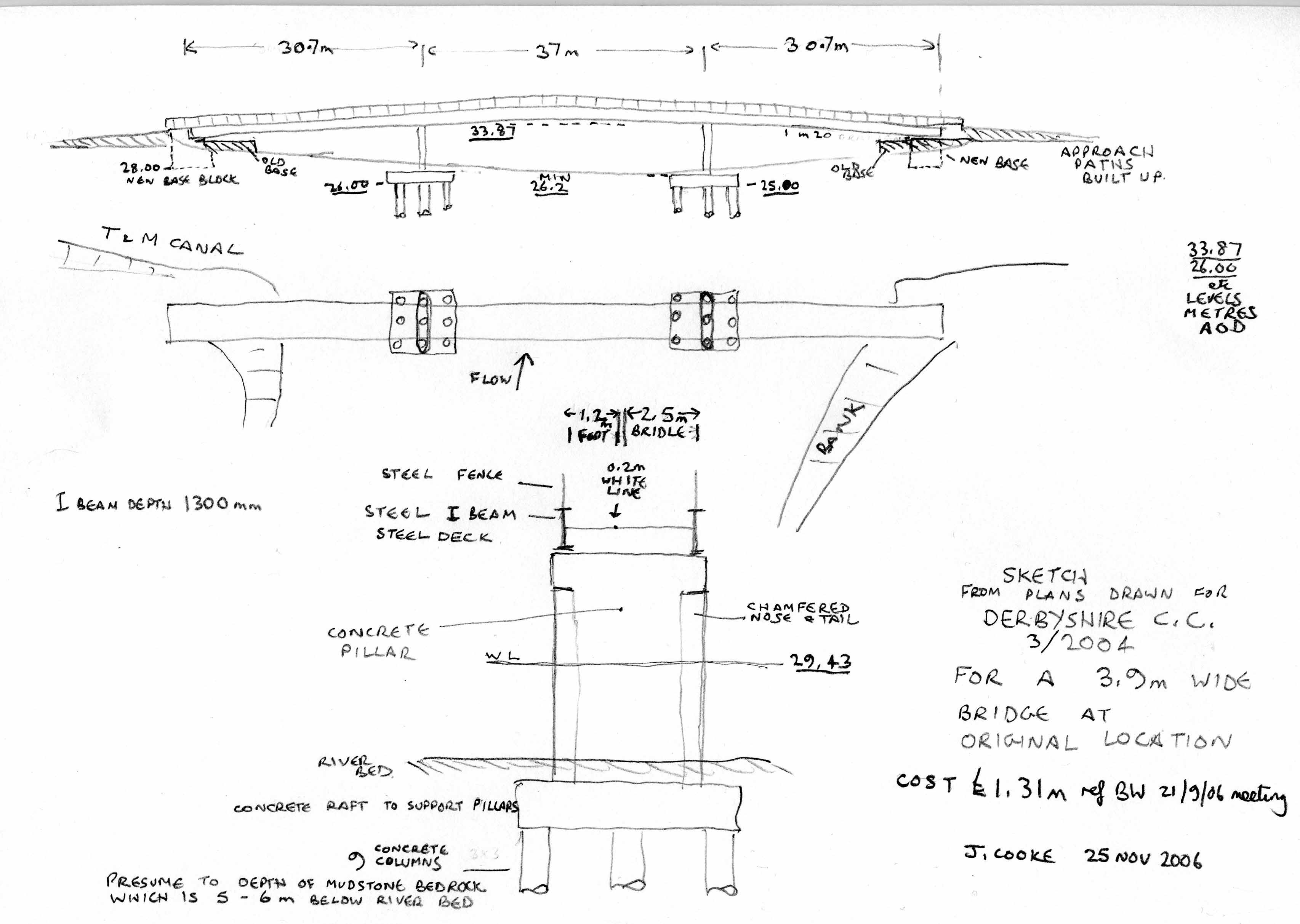
21 December 2006 - DCC supplied copy of Approval in
Principle' document, giving specification on which costing of 3.9m bridge
at original location was based (rejected on cost grounds). There is some
insight into why it was so expensive:
The document includes the following:
They considered several alternative types of design including steel/concrete
composite deck that was rejected because construction of concrete elements
over the river would be difficult and costly.
Impact loads on piers .... on the basis of a 70 tonne barge travelling
at 12mph downstream, [assuming it hits pier head on and stops within 0.2m
(due to crushing of barge).
Geological conditions: based on boring from top of bank at ends of
bridge, strata data given was:
Soft silt/clay GL - 2.6m
Sand/gravel 1.2m - 7.6m
Mudstone 6.7 - 10.5
(highly weathered to moderately weathered)
Strata profile basis for design based on above boreholes: (I presume
the following measured from river bed?)
0 - 1 m Silt/Clay
1 -4 m
Sand/gravel
4 -5 m firm clay
(weathered mercia mudstone)
5 - 8 m very stiff/hard
clay (weathered mercia mudstone)
>8 m very
weak to weak mercia mudstone
To support the high collision load on the piers, a deep foundation scheme
providing lateral resistance is adopted. Bored cast in situ concrete piles
900m dia socketed into Mercia mudstone are adopted.
From the plans, each pier is supported by 9 such piles.
The length of the piles is 14 m, which from the above means that
about 6m of pile is drilled into the bottom weak mudstone layer.
The report has much more technical information if anyone would like
to see it.
There is some correspondence included that refers to temporary stone
platforms to support the plant for constructing the piles and piers. The
report mentions coffer dams for the construction of pile cap which is below
river bed level. (concrete piers are then constructed on this base).
I think that the collision loading requirement is excessive, and that a lighter construction, protected if necessary by separate piles that BW could insert, could result in significant cost savings. For example, using the formula in the report, if the 70 tonne barge hit the bridge at a more realistic 6mph head on, and the barge crushed 0.5m rather than the 0.2m assumed, then the force on the bridge piers is reduced to just 10% of what the bridge has been designed to withstand. Couple this with a narrower 1.8m bridge, and the whole structure should be lighter and cheaper. Note that there is no statutory requirement for a specific collision load, and that the channel that passes under the bridge is a branch of the main navigation about 2 miles long leading only to a marina for pleasure craft.
My conclusion is that we urgently need public consultation for a plan and costing of an economic and functional towpath bridge, on the original site at no more than 2 metres wide, with the bridleway taking the alternative route over the existing Cavendish Bridge. John Cooke 27 Dec 2006
update 15 June 2007:
4 April 2007 question submitted for BW User Group
Meeting 25 April 2007
Long Horse Bridge - in view of the
BW budget cuts, and the widespread dissatisfaction over the current proposals,
would BW please reconsider the option to replace the LHB at the original
site as a multiuser path no greater than 1.8m wide, using a lightweight
structure similar to that proposed by BW in year 2000. See notes a, b,
c:
Note a): the Midshires Way is now proposed to follow the L91A path from its intersection with the B6540, linking with the nearby paths and underpasses at the B6540/A50 junction. The L91A and L91 paths lead to the Cavendish Bridge (London Road) Trent crossing which is regularly used by horses. As one of the options for the Midshires Way is to continue north along this same road through Shardlow, there is no justification for insisting on an additional bridleway crossing at the LHB replacement.
Note b): The latest planning application by Lafarge, following much debate, for the proposed gravel extraction at Chapel Farm (next to the T & M towpath) does not allow room for the multiuser path until after the works have been completed which is at least 5 - 6 years away. This suggests that the proposed bridleway and multi-user route is a low priority.
Note c): The LHB design that was rejected on cost grounds in Feb 2005 had provision for bridleway and was designed to withstand an extreme collision load assuming no protective fendering, which appears to have added considerable cost to the project. There must be scope for a lower cost design at the original location, and as the collision load is based on an 80 ton barge head on impact at 12 mph at 100 year flood level, it would be reasonable to expect Lafarge (the only anticipated traffic of this type) to make a significant contribution for the extra cost of this protection.
update 15 June 2007:
16 April 2007 - Shardlow PC AGM - John
Hollmes, DCC advised that plans for compulsory land puchase for the bridge
and paths are now finalised and have been submitted to land owners for
possible out of court settlement, failing which the Compulsory Purchase
process will commence. A revised planning application is being prepared
to re route the temporary access road to follow that intended for the multi
user path. i.e. instead of going directly across the fields, it will be
routed from the Wilne Lane car park immediately behind the canal towpath
hedge to Derwwentmouth, and then along the river bank. There were concerns
from the Parish over the effect on car park availability, and it was suggested
that the first section of temporary access road should avoid the car park.
When the plan is finalised, it will be made available for futher comment.
He advised that the Lafarge gravel plans will not be allowed to impact
on the route of the path, therefore the earth bunds on Lafarge plans will
need to be repositioned.
He advised that the route north out of Shardlow for the Mid Shires
Way will not be discussed for 12 months, but DCC are talking to Tarmac
about providing a bridleway bridge over the Derwent at Ambaston, where
currently there is a horse ford. The alternative is a replacement bridge
at Wilne, which is curently only 1 metre wide.
update 15 June 2007:
25 April 2007 BW User Group Meeting - BW
refused to discuss the plans in detail. They are proceeding as planned,
and if land ownership is resolved then the new bridge should be on site
August 2007. The County Council contribution remains at £280k but
there was no update of the total project cost.
update 15 June 2007:
2 May 2007 - letter to Cllr John Williams, Leader
- Derbyshire County Council
Dear Cllr Williams,
Shardlow Issues requiring your help please.
I am writing in response to your article in Insight (No 106), asking the public to tell you what we think.
Long Horse Bridge - This waterway towpath bridge was demolished
by British Waterways in 2003, and they intended to replace it by the end
of 2003. The County Coucil persuaded BW to delay the project and redesign
it to accommodate a bridleway as part of the Mid Shires Way.
There has been a delay of 4 years on the project while the County Council
resolve land ownership problems and it was only in April 2007 that the
necessary CPO’s were submitted to the landowners.
In 2003, the County Council did not have an agreed route for the paths
to the bridge and it has taken until this year for the Parish to receive
information about the proposed routing. It is now clear that the requirement
for a bridleway at the Long Horse Bridge is not justified, so that
the 4 year delay should never have happened. The path leading South
goes to the A50/Tamworth Road/ London Road interchange, and the route North
will almost certainly use London Road towards Ambaston where the is an
existing horse ford over the Derwent and the prospect of a new bridge involving
Tarmac. These routes lend themselves perfectly to using the existing Cavendish
Bridge for the bridleway to cross the Trent, this bridge being regularly
used by horses and will continue to do so regardless of any Long Horse
Bridge development.
However, the bridge design was fixed assuming that it had to accommodate
a bridleway, and as a result of budget constraints (low input from DCC?)
the bridge is being relocated 140 metres upstream where the river is narrower.
There is considerable opposition to this change (witness Cllr John Harrison’s mailbox) due to the loss of an important heritage feature – a bridge from which boats could be towed between the canal and river navigations as originally designed in the 1770’s.
If the bridleway component of the bridge was removed, the width of the bridge could be halved (similar to that proposed at Matlock), and this would enable a suitable replacement at the original site for a similar cost to the current proposal.
As the project continues to be delayed by land acquisition problems,
and is no nearer to completion than it was when first announced in 2005,
I urge you to revert to a simple replacement of Long Horse Bridge at the
original site for multi user access similar to that proposed at Matlock.
Above all we need some meaningful consultation and open debate over
the possible alternatives. It is not too late to change, what is needed
is the will to respond to the wishes of the users and the community.
update 15 June 2007:
14 May 2007 - reply from Cllr John Williams, Leader
DCC
Thank you for your letter dated 2 May 2007 informing me of issues in
Shardlow.
I have passed your correspondence on to Councillor Brian Lucas, Cabinet
Member for Environmental Services, as he has the portfolio responsibility
for these matters.
Yours sincerely
John Williams
update 15 June 2007:
17 May 2007 - reply from Cllr Brian Lucas, Cabinet
Member for Environmental Services
Dear Mr Cooke
Thank you for your email which has been forwarded to me by the Leader
of the Council, Councillor John Williams.
This is to acknowledge receipt of your email and the issues you raise
in there will be looked into and a full response forwarded to you asap.
Yours sincerely
Councillor Brian Lucas
Cabinet Member for Environmental Services
[28 June 2007 confirmed still working on reply]
see reply 2 July 2007
update 15 June 2007:
27 May 2007 letter to Caroline Killeavy, General Manager
BW East Midlands
Thank you for the offer in the recent User Group Minutes 'to share
detailed information about plans and costs with any member interested,
just contact the office'.
Having been disappointed that you have refused to discuss my pre-notified questions at the last 2 User Group meetings, I now request detailed information as follows:
1. In the design rejected on cost grounds, what is the basis for BW insisting on a collision loading for a 70 tonne barge travelling at 12 mph at 100 year flood level? What evidence do you have that the river current would be sufficient at this location to cause such an excessive speed, noting also the craft speed limit in force which is speed relative to land?
I am very concerned that this design assumption alone has been a major factor in the higher than expected cost of the original design, and that from my observation the river current here never exceeds 4 mph and in fact is slower at 100 year flood conditions due to the increased cross section that is then available.
This question is of great significance, because collision loading increases by the SQUARE of the vessel speed, hence the effect on cost of the resulting structure.
2. In the design rejected on cost grounds, the cost of piling for the piers was a significant factor. I have been advised by a Civil Engineer that with mudstone bedrock being 5 - 6 metres below river bed, a more economic method to create pier foundations would be to excavate within coffer dams to bedrock and fill with concrete. This avoids the need for heavy piling equipment, for which the plans had required expensive temporary roadway across fields and temporary platform in the river.
Was this option considered?
3. Were the above questions properly reassessed before the decision to relocate the bridge?
4. In view of increases in general construction costs, particularly steel, what is the true cost comparison between the current proposed design and that which could be achieved at the original location, noting that a 1.8 metre width is sufficient for a multi user bridge (excluding bridleway, which can be routed over Cavendish Bridge as previously explained).
5. Would a concrete construction by cheaper? (It seems to be the preferred method on the river Thames)
Please may I remind you of the considerable unrest that exists over the current plans, as witnessed by the volume of past correspondence to BW and DCC. The concerns have not gone away, and we seem to be no closer to obtaining a replacement bridge than we were in Feb 2005 when the new design was first indicated.
The new information about path routes that has only come to light in recent months really does remove the case for insisting on a bridleway across this bridge, and I have separately asked DCC to reconsider the LHB replacement bridge proposals. [to revert to a simple replacement of Long Horse Bridge at the original site for multi user access similar to that proposed at Matlock, 1.8 metres wide.]
In the light of concerns over the current plans and uncertainty over resolving the land acquisition problems, I feel it appropriate to look again at what could be achieved at the original site.
My prime objective is to preserve the heritage value of this important waterways junction.
I shall be away for most of June, but look forward to your reply on
my return.
Best wishes
update 15 June 2007:
31 May 2007 - reply from BW
Dear Mr Cooke
Thank you for your e-mail to Caroline Killeavy of 27 May 2007 requesting
information
under the provisions of the Freedom of Information Act 2000.
You have requested information regarding the design of the replacement
of Long
Horse Bridge.
I can confirm that a full response to your request will be sent within
a 20 day working
timescale from the date we received your correspondence which will
be no later than
25 June 2007.
Liz Horne
External Relations Administrator
22 June 2007 reply from BW
22 June 2007
Mr J Cooke
Shardlow Heritage Trust
Ref: (please quote in all correspondence) FOIA24/07
Dear Mr Cooke
I write further to my letter of 31 May 2007 and am responding to your
request for information under the provision of the Freedom of Information
Act 2000. Your request concerns the design of the replacement of Long Horse
Bridge.
The following are your questions and British Waterways answers:
1. In the design rejected on cost grounds, what is the basis for BW
insisting on a collision loading for a 70 tonne barge travelling at 12
mph at 100 year flood level? What evidence do you have that the river current
would be sufficient at this location to cause such an excessive speed,
noting also the craft speed limit in force which is speed relative to land?
I am very concerned that this design assumption alone has been a major
factor in the higher than expected cost of the original design, and that
from my observation the river current here never exceeds 4 mph and in fact
is slower at 100 year flood conditions due to the increased cross section
that is then available.
This question is of great significance, because collision loading increases
by the SQUARE of the vessel speed, hence the effect on cost of the resulting
structure.
The major cost issue in relation to bridge piers in the river is that they are expensive to construct compared with land based abutments. The collision loading capacity of the piers is not a significant factor in this cost difference.
2. In the design rejected on cost grounds, the cost of piling for the
piers was a significant factor. I have been advised by a Civil Engineer
that with mudstone bedrock being 5 - 6 metres below river bed, a more economic
method to create pier foundations would be to excavate within coffer dams
to bedrock and fill with concrete. This avoids the need for heavy piling
equipment, for which the plans had required expensive temporary roadway
across fields and temporary platform in the river.
Was this option considered?
Piling equipment will be required for both options. There is no significant difference in cost between the two options.
3. Were the above questions properly reassessed before the decision
to relocate the
bridge?
Yes.
4. In view of increases in general construction costs, particularly steel, what is the true cost comparison between the current proposed design and that which could be achieved at the original location, noting that a 1.8 metre width is sufficient for a multi user bridge (excluding bridleway, which can be routed over Cavendish Bridge as previously explained).
The cost differences will be similar.
5. Would a concrete construction by cheaper? (It seems to be the preferred method on the river Thames)
No.
If you are not satisfied with our response to your request then please
write in the first
instance to Eugene Baston, External Relations Manager, British Waterways,
Willow
Grange, Church Road, Watford WD17 4QA (Telephone 01923 201350) detailing
your case.
The office of the Information Commissioner is the organisation that
ensures compliance with the Freedom of Information Act 2000 and deals with
formal complaints. If we have not been able to resolve your complaint you
are entitled under section 50 of Freedom of Information Act 2000 to apply
to the Information Commissioner for a decision. His contact details are:
Information Commissioner, Wycliffe House, Water Lane, Wilmslow, Cheshire,
SK9 5AF
Or
Enquiry/information line: 01625 545 745
Email: data@dataprotection.gov.uk
Many thanks.
Yours sincerely
Liz Horne
External Relations Administrator
29 June 2007 letter to Eugene Baston, BW External Relations
Manager
Dear Eugene Baston,
LONG HORSE BRIDGE REPLACEMENT, SHARDLOW - FOIA24/07
I refer to the reply 22 June from Liz Horne at Willow Grange, to my e-mail 27 May to Caroline Killeavy at Newark.
I am not satisfied with the response because it does not answer the questions, and answers appear to have been made up with little reference to the facts.
• Question 1 asked about the basis of the collision loading and for
evidence to justify the assumed vessel speed at the original bridge location
and this was not answered.
The answer needs to provide evidence to justify the assumed vessel
speed, noting that there is a speed limit in force on the navigation.
If the collision loading really did not have any influence on the design
of the piers and their foundations, the answer should have supplied this
evidence from the design calculations.
• Question 2 asks if an alternative cheaper method to create pier foundations
had been considered. The answer given was that piling equipment will be
required for both options, and that there would be no significant cost
difference. However, there is a huge difference in the scale of piling
equipment that is required depending on which option is considered, and
a coffer dam could be created from floating plant rather than the very
heavy land based equipment that was required for the 2004 design.
Could you please supply facts to support the statement that there would
be no significant cost difference.
• Question 4 asks for an assessment of the cost for a bridge at the original location, but less than half the width of carriageway, and to compare this to the true cost of the current proposal. No figures were supplied.
• Question 5 asks if a concrete construction would be cheaper, this being the preferred method on the river Thames. No evidence was supplied to support the answer ‘no’.
I do hope that the BW decision to answer my questions under the Freedom of Information Act has not constrained the scope of the answers.
Throughout my dealing with BW on this matter, my questions have been sidestepped. There has been no meaningful dialogue on the bridge design.
During this time there has been new information from the County Council on the proposed routes for the multi user path and bridleway which leads to there being no case for insisting on a bridleway on this bridge, hence the carriageway need only be 1.8 metres wide as proposed at Matlock for similar use.
I have seen no evidence of any real attempt to make cost savings on the proposed structure at the original location, other than by relocating the bridge and thus removing an important Waterways Heritage feature for ever. Nor was there any discussion with user groups or local community before the current plans were drawn up. That is inexcusable.
I have seen no evidence of continued attempts to obtain the necessary funding to enable a suitable replacement at the original location since the current unsatisfactory proposal was hurriedly decided upon at the end of 2004.
It does seem incredible that BW are unable to attract more funding on this project from other sources, or indeed central government, at a time when Nottingham City Council is proposing a completely new multi-user bridge at Beeston for about £2m of which Sunstrans would contribute £1m.
I continue to press for a review of the options and a real attempt to
retain what was an important and significant Heritage Feature of the waterways
– a suitable design at the original location.
John Cooke, Shardlow Heritage Trust [for reply see 17 Aug
]
2 July 2007 - reply from Cllr Brian Lucas re my letter
14 May to Cllr John Williams:
With regard to the replacement of Long Horse Bridge and associated
access links, the County Council has considered very carefully all the
options available. As officers have already pointed out to you in previous
correspondence, to replace the bridge at the original location would cost
an additional £750,000 of taxpayers money. By rebuilding the bridge
140 metres upriver, we, together with our partners in this scheme, British
Waterways and Leicestershire County Council, are able to deliver a multiuser
crossing of the river within budget, which will open up the riverside environment
for all to enjoy: not just a pedestrian crossing, but access for disabled
people, cyclists, families with buggies and horse riders.
Whilst I share your frustration at the delay in replacing the bridge,
this has been through no fault of the local Authorities. Cabinets of both
County Councils have approved the required Compulsory Purchase Order and
it is now being implemented. I would like to reassure you that my officers
are doing all that they can to deliver this scheme as soon as possible.
I hope you will be interested to know that the application has now
been submitted for the multi-user trail to access the approved replacement
bridge (in the first instance it will be used to access the construction
works for the bridge). The Council will be giving appropriate publicity
to this application, and I hope you will let us have your views on it.
Yours sincerely
Councillor Brian Lucas
Cabinet Member for Sustainable Communities
14 July 2007 - my reply to Cllr Brian Lucas
Contrary to your letter, I cannot find a previous reference to a cost
difference of £750,000 . The most I have seen is ‘between £400k
and £500k’, but that was relative to a 3.9 metre wide bridge including
bridleway – which, as I have pointed out, is not justified.
Therefore the true cost difference should be less than £200k, as indicated by figures supplied by British Waterways. In September 2006 we were told that the estimate for a 2.0 metre wide bridge at the original location was £1071k, compared to £881k then quoted for the current proposal. The difference was £190k.
However, what we are lacking is a true present day comparison between these two options, and in view of the recent information on path routes leading to the bridge, we should now be seeking a more appropriate solution that reflects the heritage value of this important site. This should include efforts to reduce costs by reassessing the barge collision load (12 mph is excessive), and adopting a cheaper method of construction for the pier foundations, both of which have been suggested to British Waterways.
I say again:
Above all we need some meaningful consultation and open debate
over the possible alternatives. It is not too late to change, what is needed
is the will to respond to the wishes of the users and the community.
John Cooke, Shardlow Heritage
16 July 2007 reply from Cllr Brian Lucas
Thank you for your recent e-mail and letter of July 4th.
I think you are comparing the cost of a 3.9m wide bridge at the new
location with a 2m wide bridge at the original location, using a combination
of original estimates with up to date estimates, to arrive at your figures.
The situation is further complicated insofar as three different bridges
have now been designed and costed.
I believe Mr Brian Martin of our Consulting Engineers has provided
you with the relevant information following your FOI request back in December
2006. The lowest tender price we received for the 3.9m wide bridge in its
original location was £1.174million at June 2004 prices. Having checked
the latest price indices a revised figure for the original 3.9m wide bridge
would be around £1.5 million. This year's revised estimate for the
3.9m wide bridge at the new location is around £850,000.
The fact that remains, is that substantial savings will be made to
the public purse by relocating the bridge structure to its new location.
The issue surrounding multiuse access has been debated extensively and
the consensus is that full and socially inclusive access is the desired
outcome of the project. The scheme has gone before both Cabinets of Derbyshire
& Leicestershire County Councils and has been approved.
Your reference to reviewing barge collision loads and pier foundation
construction methods is not really acceptable. We must be guided by the
professionalism and expertise of our engineers in these matters. Their
specifications will have been arrived at for a reason and we must accept
that.
It is unfortunate that the replacement of this bridge has become a protracted
affair. The CPO has now been approved by both County Council Cabinets and
the process is now regaining momentum. I trust you will share in the consensus
view that the many social and environmental benefits to be had by rebuilding
Long Horse Bridge in its new location are in the public interest and the
scheme enjoys widespread support.
23 July 2007 - my reply to Cllr Brian Lucas
Thank you for your letter 16 July.
The costs that I quoted to you were presented by Caroline Killeavy
(BW) at a meeting of waterways user group representatives 21 Sept 2006,
and were used then to compare the costs of the alternatives. The difference
between a 2.0m wide bridge at the original location and the 3.9m bridge
at new location was £190k. The cost of the current proposal was then
given as £881k.
In March 2005, the BW feasibility report gave the cost of the current
proposal as £943k, so it had apparently reduced since then.
It is not acceptable to take a June 2004 price and apply a cost increase
based on indices, particularly when you now quote £850k for the new
bridge which is lower than either of the above figures. It is inconsistent
to quote reducing costs for the current proposal and then assume a significant
cost increase for the alternatives.
What we need is a genuine attempt to cost an economic replacement at
the original site, noting that a width of 2.0m is adequate for multi user
access (the bridleway using Cavendish Bridge), and that the reduced width
is indeed necessary to reduce the risk of misuse by off road vehicles and
itinerants.
Regarding the collision loading, whilst we should be guided by the
professionalism and expertise of the engineers, it is also appropriate
to question them and request evidence to support the assumptions on which
the design is based. I await a reply from British Waterways on the basis
of their collision loading requirement.
25 July 2007 - reply from John Holmes for Brian Lucas,
DCC
Brian Lucas has asked me to reply to your letter of 23rd July.
I appreciate your confusion at prices quoted for the bridge. This is
because we have now designed three different bridges. The original BWB
2m bridge, the 3.9m DCC (Scott Wilson) bridge at the original location
and the 3.9m BWB bridge at the new location. These have had estimated costs
put against them, actual tender costs and present day estimated costs adjusted
for rising steel prices and inflation.
The fact that remains, is that we are able to build a fully accessible
multiuser bridge 3.9m wide at the new location (estimate £850,000)
at a considerable saving to the taxpayer, based on a comparison against
a 3.9m wide bridge at the original location ( last estimate was circa £1.5million,
based on an adjustment to the actual tender of £1.2million).
A 2m wide bridge is no longer an option at any location.
A multiuser bridge must be at least 3.9m wide. Access controls will
ensure “off-road vehicles and itinerants” do not enter the site.
You are free to question BWB Engineers regarding collision loading
advice for the new bridge structure. I am not a qualified Engineer and
I must rely upon their professional advice in these matters.
17 August 2007 - reply from BW to my letter 29 June
British Waterways answers:
• Question 1 asked about the basis of the collision loading and for
evidence to
justify the assumed vessel speed at the original bridge location and
this was
not answered.
The answer needs to provide evidence to justify the assumed vessel
speed,
noting that there is a speed limit in force on the navigation.
If the collision loading really did not have any influence on the design
of the
piers and their foundations, the answer should have supplied this evidence
from the design calculations.
The design of any bridge piers in the river has to take account
of the possibility of
errant, adrift vessels in flood conditions. Craft up to 70 tonne
can use this section of
navigation and flood velocities of 12mph can be experienced at this
location. These
factors have been considered in the design process.
• Question 2 asks if an alternative cheaper method to create pier foundations
had been considered. The answer given was that piling equipment will
be
required for both options, and that there would be no significant cost
difference. However, there is a huge difference in the scale of piling
equipment that is required depending on which option is considered,
and a
coffer dam could be created from floating plant rather than the very
heavy
land based equipment that was required for the 2004 design.
Could you please supply facts to support the statement that there would
be no
significant cost difference.
No heavy, land plant, was costed into the 2004 design for pier construction.
The
most economical method of cofferdam construction was proposed, using
waterborne
plant, with the foundations constructed within the cofferdam, using
piling rigs.
• Question 4 asks for an assessment of the cost for a bridge at the
original
location, but less than half the width of carriageway, and to compare
this to
the true cost of the current proposal. No figures were supplied.
Comparison of the bridge option costs was carried out in 2005. The
cost of a bridge
at the original location, 2.0m wide, (which is the minimum width
of a public highway
bridge), was £1,071,000. This compares with £881.000
for a 3.9m wide bridge at the
new site, less £280.000 grant funding towards the bridleway,
gives a net cost of
£601,000.
• Question 5 asks if a concrete construction would be cheaper, this
being the
preferred method on the river Thames. No evidence was supplied to support
the answer ‘no’.
No detailed costings to compare a steel and concrete form of construction
for a
bridge at the original location was undertaken. This decision was
made on the basis
that for such a long span, over water, the costs of; temporary works,
shuttering, on
site reinforcement fixing, concrete placement, extra time on site
and disruption to
navigation would be far greater than offsite steel fabrication,
delivered ready for
erection.
If you are not satisfied with our response to your request then please
write in the first
instance to Eugene Baston, External Relations Manager, British Waterways,
Willow
Grange, Church Road, Watford WD17 4QA (Telephone 01923 201350) detailing
your case.
29 August 2007 - my reply to British Waterways
My original question 1 to Caroline Killeavy (e-mail 27 May 2007)
was:
‘1. In the design rejected on cost grounds, what is the basis for BW
insisting on a collision loading for a 70 tonne barge travelling at 12
mph at 100 year flood level? What evidence do you have that the river
current would be sufficient at this location to cause such an excessive
speed, noting also the craft speed limit in force which is speed relative
to land?
I am very concerned that this design assumption alone has been a major
factor in the higher than expected cost of the original design, and that
from my observation the river current here never exceeds 4 mph and in fact
is slower at 100 year flood conditions due to the increased cross section
that is then available.
This question is of great significance, because collision loading increases
by the SQUARE of the vessel speed, hence the effect on cost of the resulting
structure.’
The latest reply [‘flood velocities of 12 mph can be experienced at
this location’] still fails to give any evidence of the river current ever
exceeding 4 mph at this location. I have travelled upstream here on a narrowboat
with ease when the river was flooding the fields and flowing over the towpath
below Derwentmouth Lock. As the river rises still further, it also
flows across the fields towards Sawley and there is no evidence that the
current at the original bridge location would increase.
To suggest that the current here could reach a speed of 12 mph is simply
nonsense; therefore the bridge design, rejected on cost grounds, was designed
to withstand an excessive collision requirement.
Re the reply to Question 4, the cost comparison for a bridge 2m wide at the original location showed a saving of £190k for the current design. It is wrong to then assume that the grant funding would no longer apply to a 2m wide bridge, because the resultant bridge would still be multi user with access for cyclists and disabled. It is only the bridleway that would take the alternative route over Cavendish Bridge. I would add that in my view BW are bearing far too high a proportion of the costs, with the County Councils contributing very little to the cost of the bridge on which they have imposed their requirements.
The above two points demonstrate that the current plans are proceeding on a false basis. In view of the large number of objectors to the current plans, I continue to press for a review of the options and a real attempt to retain what was an important and significant Heritage Feature of the waterways – a suitable design at the original location.
14 September 2007 BW reply:
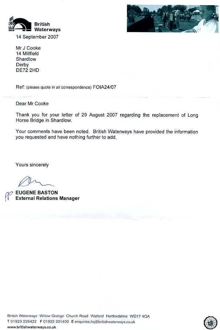
10 December 2008 - notes from public meeting at Shardlow
A public meeting was held at Shardlow on 10 December 2008, to view
the latest plans for the bridge and the path leading from it to Shardlow.
The plans were presented by John Holmes from Derbyshire County Council’s
Countryside Service, and about a dozen people attended.
There was no change to the proposed bridge design, a bowstring design
sited 140m upstream where the Trent is about half the width compared to
the site of the previous bridge. I reminded Mr Holmes of the many objectors
to this design, and he replied that many more people had contacted him
being only concerned that a replacement be provided soon.
The meeting focussed on the multi user and bridleway path route from
the bridge to Shardlow. This will be from the bridge along the Trent west
bank to Derwentmouth, then follow the existing canal towpath for about
half the distance to Derwentmouth Lock, at which point it will cross the
hedge line to continue behind the towpath hedge all the way to the nearest
corner of the car park in Wilne lane, have turned away from the canal at
that point. After entering the car park, the path follows the east and
south perimeters to arrive at Wilne Lane next to the vehicle entrance,
which may need to be moved to one side. The path will be used for construction
vehicle access to build the bridge abutment and embankment on the west
bank. The bridge itself will be assembled on the Leicestershire side (east
bank). The path will be finished with a hard surface ‘toptrec’.
There were detailed questions concerning flood levels and the effect
on the path (the Trent section will flood as the EA will not allow it to
be built up). The bottom end of the towpath also floods. The protection
of mature trees at the car park entrance was another concern which will
be assessed when detailed plans are submitted for planning approval.
The route for the path from the car park towards Derbyshire was given
as Wilne Lane to London Road (Navigation Inn), then London Road to Ambaston
Lane (Shardlow primary school), down Ambaston Lane to Ambaston where there
is an existing horse ford across the Derwent. This could be upgraded to
a bridge if gravel extraction plans generate such a crossing. Since the
meeting Mr Holmes has advised that this route is for horses and cyclists,
and that pedestrians would probably be directed to cross the Derwent at
Wilne where there is a small footbridge. This is the existing route of
the Derwent Valley Heritage Way.
In view of the bridleway using London Road, I suggested that horses
could take an alternative route up the east bank of the Trent and cross
at Cavendish Bridge which has plenty of room for a bridleway. This would
allow the Long Horse Bridge replacement and new path to be much reduced
in width, saving money (which could help finance a more suitable replacement
bridge at the original location). Mr Holmes replied that the County Council
take bridleways off roads wherever possible, so would not agree to such
a proposal.
Public Enquiry :-
Mr Holmes explained that one of the landowners on the route to the
car park had failed to agree to the Compulsory Purchase Order submitted
by the County Council. As a result, there will be a one day Public Enquiry
some time in the new year. Meanwhile the County Council will process their
Planning Application for the proposed path. Dates to be advised for both
these events.
Conclusion:-
The authorities continue to pursue their plans with no intent of changing
to suit the objections to the new bridge design. Could the Public Enquiry
present an opportunity for a rethink?
Addendum to 12 Dec 2008 meeting notes
Costs
The money being spent on the new project is mainly from BW. Mr Holmes
advised that the total budget is £1,272,000 of which about £250k
comes in grant aid, £50k from DCC, a small amount from Leicestershire,
and the remainder from BW. In return for BW paying most of the cost, the
County Council will take over responsibility for maintenance of the bridge.
Is this really a good deal for the waterways? We lose an important heritage
feature and pay for a new multi user bridleway link that has little relevance
to most boaters. Surely if c £900,000 is to come from BW then we
should at least expect to maintain the important heritage aspects of this
waterways feature, and that means a bridge at the original location to
a design that allows boats to be hauled from the bridge between river and
canal.
March/April 2009 - Planning Application for path Shardlow
to LHB replacement
The Planning Application for the new multi-user path and bridleway
from Shardlow to the proposed resited bridge was still open at 6 April
2009, with no date set for determination because further information has
been requested by Consultees.
[update 4 Dec 2009: the plans were approved on 28
Ocotober 2009]
To see the plans and correspondence, go to the Derbyshire County Council
web site and find Environment/Planning/Planning Applications/Current Applications
to enter the application number CD9/0808/69. On the next screen click on
the application number to go to the case file from which you can access
the plan, consultee responses, representations etc
http://www.derbyshire.gov.uk/environment/planning/planning_applications/current_applications/default.asp
To send your comment on-line, the link 'Comment on this Application'
is at the top of the case file page. It leads you to a page with a very
small text box, but able to take a large amount of text - so best done
by copying and pasting into it from your own prepared document. [update
4 Dec 2009: the plans were approved on 28 Ocotober 2009]
25 March 2009 Public Inquiry into multi-user path and bridleway to Long Horse Bridge
A Local Public Inquiry was held at Shardlow on 25 March 2009, over the Compulsory Purchase of farmland for a multiuser path and bridleway from Shardlow to the planned replacement for Long Horse Bridge.
Objections were heard from the farmer, Inland Waterways Association, Shardlow Heritage Trust, HistoricNarrow Boat Owners Club, Association of Waterways Cruising Clubs, and others who want a replacement for LHB at the original site not 140m upstream, 2m not 3.9m wide, with the bridleway sent over Cavendish Bridge on the same road that will take it through Shardlow anyway. It would then only require sympathetic towpath improvements to accommodate cyclists etc, rather than the proposed new track behind the hedge and the removal of historic bridge abutments.
Supporters of the scheme were DCC and a number of people representing equestrian interests. They want the bridleway route to be off-road as much as possible. The saving is about 400 yards of roadway.
The Inspector hoped to complete his report to the Secretary of State by mid April, following which a decision on the CPO will be made.
The general feeling of the objectors is that DCC and BW have acted to suit the equestrian lobby, at the expense of losing an important heritage and functional towpath river bridge, to be paid for principally by BW. The County Council are putting in a fixed £50k plus £250k of grant money, while the BW share has steadily increased from an original £575k over £1.0M at the last quote.
How can this use of BW funds be justified – for a bridge that would be of little use to waterway interests?
Compare this to the activities of the Lincolnshire Waterways Partnership, (LCC, EA and BW) who in the last 5 years have funded numerous waterside projects, including bridges, at comparatively little expense to BW. (LCC £8.6M, Grants ERDF£4.2M, Grants emda £2.9M, Private sector £234k, EA £220k, BW £118.5k)
29 September 2009 - new management at BW receptive to a rethink
Quote from e-mail from Acting General Manager, British Waterways -
East Midlands:
The bridge location was moved to reduce the cost of the project and
moving it back to the original location would increase costs. The route
we have gone down is now awaiting the decision from the secretary of state,
which I undertand is imminent. I believe we should wait for that decision.
If it prevents to project in its current form, I agree, that the project
details should be reconsidered and the option of moving back to the original
location should be looked at along with the form of the bridge.
1 December 2009 - Secretary of State for Transport CONFIRMS the Compulsory
Purchase Order
The Public Local Enquiry held 25 March 2009 resulted in the inspectors
CPO Report to the Secretary of State for Transport, dated 27 April 2009
(copied to objectors on 1 December 2009), and the Secretary of State's
decision on this was received by letter dated 1 December 2009, confirming
the CPO.
The inspector's report and decision letter can be found at:
http://www.gos.gov.uk/gone/transport/casework/laos/decisions/
under Derbyshire County Council Long Horse Bridge Shardlow.
This means that the County Council can purchase the land required for
access to constuct the bridge, and the same land will be used for the multi
user path.
Earlier, on 28 October, the County Council granted planning permission
for the new path. There were requirements for more detailed information
that must be approved by the County Council Planning Authority before works
commence - such as space for site accommodation, storage of plant and materials;
precise details of the path fencing and of the barrier (that demarcates
the section of tp that is shared by the trail) across the towpath below
DWM lock; written scheme of archaeological investigation; method of stripping
and storage of soil; detailed planting scheme; survey of all existing trees
within 5 metres of proposed development and measures to protect or detailed
justification for felling or lopping.
8 October 2010 DCC take Shardlow Parish Council and
Shardlow Heritage Trust along route of proposed multi user path (Wilne
Lane car park to Derwentmouth)
The original plan was to make an essential roadway for construction
plant first, and use this as the basis of the final path. During the walk
we were advised that the current plan is to lay 'bog matting' along the
proposed path route for bridge construction access, then work back from
the bridge removing the matting and laying the greenway path. A significant
change post planning and public enquiry.
Detailed questions such as which trees might be affected and suggestions
to revise the planned car park entrance arrangements (to avoid removal
of trees) require further responses from DCC
24 November 2010 British Waterways (Alex Lee) Presentation
to Shardlow Parish Council
Construction work is due to commence January 2011, and allowing 30
weeks for bridge construction plus 10 weeks for greenway path construction,
the target is for an October 2011 opening.
A number of questions were raised over the operation and its effect
on residents and landowners. There are also outstanding items re the conditions
attached to the Planning Approval which must be resolved and communicated
to the Parish Council before work commences.
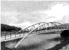
5 November 2011 - we see
an explanation of how the project came about, on the website
www.bridleways.com, current link(at 3 Jan 2012):
http://www.bridleways.com/bridleways/hot_news_and_events/Entries/2011/9/30_the_new_Long_Horse_Bridge_over_the_R.Trent_to_link_Leicestershire_and_Derbyshire_and_carry_the_Midshires_Way.html
text copied below
3 January 2012 - the new path and bridge have been
in use since November 2011 although there has been no official opening
to date.
1. Nov 2002 NW Leics N parishes cylcing network plan - extract
of document found on web (below this list)
2. J Cooke letter to Cllr Brian Lucas 2 May 2006 - need revert
to original site plus Q's on connecting paths link
3.Waterways Ombudsman's report into complaint over lack of consultation
link
to page
4. Some extracts re BW policy and responsibilities link
5. Text of bridleway.com statement on how the authorities were persuaded
to replace Long Horse Bridge link
1. Nov 2002 NW Leics N parishes cylcing network plan - extract of document found on web:
1126
North West Leicestershire
NORTHERN PARISHES CYCLING
NETWORK PLAN
Introduction
1.1 This report, prepared for North West Leicestershire District
Council by Sustrans, presents a Cycling Network Plan for the Northern Parishes
of the District. Implementation may be secured with particular help
from Leicestershire County Council, the Government Office for the East
Midlands, the Highways Agency, National Forest Company, East Midlands Airport
and key landowners.
3.3 This issue [1st November 2002] represents the post-consultation draft for consideration by Members of North West Leicestershire District Council.
If / when the Council approves the report, a number of its recommendations will need further discussion in the communities most closely involved besides also being subject to land availability and civil engineering constraints.
66. Midshires Way runs up from Buckinghamshire. As far as Warren
Lane [12-13-
67-68 15], it is enjoyed by walkers, cyclists and horse riders.
Northwards from Sawley it serves only walkers due to lack of a suitable
Trent crossing and to difficulties in safely accommodating horses on the
busy local road network.
Longhorse Bridge [67], crossing the Trent just east of Great Wilne, is currently closed for renewal. Fundraising is in hand for a new structure that is planned to serve cyclists and horses as well as walkers. The project partnership includes British Waterways, several Local Authorities and the British Horse Societey.
Besides the bridge itself, approaches would be needed from the
B6540 [65] where a signalled crossing would be essential. Between
65 and 66 a route could be made alongside the [possibly to-be-widened]
M1. From 66 to 68 a new path could be created on land adjacent to
the towpath. At 68, riders would join an existing lane.
69 To accommodate horse-use northwards from Great Wilne, the present
Midshires Way footpath would have to be re-categorised as a bridleway.
The Derwent bridge would also have to be replaced by a structure with wider
deck and higher parapets.
next para amended 17 September 2006 re letter resend
I continue to be in correspondence with British Waterways over the unsatisfactory consultation regarding navigational requirements of the proposed bridge, and attach for your information a copy of my 20 March letter to the Waterways Ombudsman, which expressed my concerns over the present proposals.
I have the following additional concerns over the current proposal:
• The DCC involvement is to support a proposed bridleway (the Mid Shires
Way) and a multi user path. At present the towpath from Shardlow to the
bridge is unpaved and narrow in places. DCC have advised the Parish Council
that the multi user path would be on the south side of the towpath hedge
(ie in the fields). The fields in question are subject to a planning application
for gravel extraction, which the village is vigorously opposing. There
is a brook running through the fields, at places close to the towpath,
and natural boggy areas supporting a wealth of wildlife. There has been
no consultation over the provision of the proposed path.
• On the Leicestershire side of the bridge, the route is along the
river towpath to Sawley bridge. This is an even narrower path, and presumably
the same angling interests who are objecting to the bridge abutment own
the adjacent land. There are additional problems with structures on this
section, including a concrete bridge in poor condition over a watercourse
and a cantilevered section of path as it passes under a large water main
pipe bridge. These structures are narrow and presumably would need replacing.
Finally at Sawley bridge there is a busy road to be crossed and a length
along this road to Warren Lane, the current end of the Mid Shires Way in
Leicestershire.
• So for about a mile or more either side of the proposed bridge there
is no suitable track for multi user path or bridleway, and no consultation
over any plans to resolve these issues. The new bridge, if proceeded with
at it’s 3 times the previous width (unjustified), will be a white elephant
taking no more traffic that the previous bridge – which had ample scope
for many times the amount of traffic that used it.
In view of all these concerns, I would urge you not to commit to the current plans but to reconsider a replacement in the style and location of the previous bridge.
Would you please reconsider and provide answers to the following questions?
1. What is the justification for the 3.9 metre width of the proposed
bridge? Please provide detailed reasoning for this, and advise how a similar
standard is to be achieved throughout the distances between Sawley village
(including Harrington Bridge with narrow walkways) and Shardlow village;
and between the current end of the mid Shires Way at Warren Lane, Sawley
and the Derwent Valley Way at Great Wilne. Please advise specifically why
a 2.0 metre width of bridge would not be permissible.
2. What is the justification for selecting a bridge design that requires
a 1 mile temporary roadway to be constructed across farm fields to enable
the bridge to be brought on site, compared to a trestle bridge that could
be brought in smaller sections by water?
3. To what extent has the proposed gravel extraction at Chapel Farm
influenced the bridge design?
Please take into account the historic and functional importance of the Long Horse Bridge. The original bridge was constructed c.1770 as part of James Brindley’s Grand Cross canal scheme, and the 1934 concrete replacement followed the style and alignment very closely indeed. Why cannot we do as good a job in 2006?
This topic is now being aired in the Waterways World magazine, and it would be good to see a positive response from the County Council to the concerns being expressed by waterways users.
4. Some extracts re BW policy and responsibilities:On accountability British waterways website says:
“Accountability
As a public corporation, British Waterways manages and cares for
the waterways on behalf of the nation. The British people are our stakeholders
and customers on many different levels. Through their taxes, they help
fund the network, and so have every right to demand that we fulfil our
responsibilities prudently and effectively.
Our canals and rivers pass through local communities across the length and breadth of the country. Waterway development is often closely linked to community aspirations and social issues at the local level. It is essential that the views of local communities are fully represented and effectively listened to.
We are committed to getting the processes of dialogue and accountability absolutely right. We believe that the integrity of decision making that will result from the right processes will benefit customers, users of the waterways and other stakeholders, as well as enhancing the security and long-term future of the waterways themselves.”
5. Text of bridleway.com statement on how the authorities were persuaded
to replace Long Horse Bridge
Long Horse Bridge carried the towpath of the Trent & Mersey Canal
over the Trent at the watery cross roads where the Canal goes through "Derwent
Mouth" where the Trent and Derwent meet, leaving Leicestershire to go into
Derbyshire.
In April 1994 the Federation of E Midlands Bridleways Associations was
excited by the imminent opening of the long-distance riding route, the
Midshires Way but concerned that a lack of connected bridleways in Derbyshire
meant it was only a walking route in that county.
An informal riding route had been mapped out, which started with half
a mile of the very busy B6540 between Sawley Marina and Sawley village
over the long and narrow Harrington Bridge. FEMBA looked for another route
and its committee walked along the canal towpath from near the Marina to
Long Horse Bridge, where they found a long, narrow concrete bridge showing
signs of extreme dilapidation although the remains of its predecessor could
still be seen below. Curving up over the R.Trent, it was impossible
to see anyone starting from the other bank and would be very difficult
to pass them if met mid-bridge.
It was clear that the Long Horse Bridge could not be used by horses until it was rebuilt. And the footpaths leading to and from it would have to become bridleways.
There matters stayed until Vicky Allen, Chair of Leics & Rutland Bridleways Assn, investigating three planning applications for distribution centres at the M1/A6-A50/A453 cross roads, in NW Leicestershire District Council's offices on 4 February 1999, was shown an application from British Waterways to rebuild Long Horse Bridge to footpath standard.
This was the signal for a bout of lobbying to get the bridge built to
bridleway standard and for the creation of bridleways that would carry
the Midshires Way for horses safely between the B6540 and Shardlow and
then up through the Wilnes, following the route chosen for walkers.
The Federation and its constituent Bridleway groups got to work on the two county councils, British Waterways and NWLDC as the planning authority. The status of the Way was a key factor in getting agreement in principle fairly quickly for a "bridleway" bridge, which would also provide more room for kit-laden anglers. British Waterways committed the £800k it had budgeted for the foot bridge to the project.
In spite of the bridge being, just, in Leicestershire, Derbyshire County
Council became the lead partner in the project to build the new bridge
and create the bridleways to and from it. They were able, in the
2002/3 estimate for the bridge, to win £100k from Landfill Tax, and
a gravel extraction application on the Derbyshire bank was granted with
a commitment to dedicate a bridleway parallel to the towpath to Shardlow
on what was expected to be the route for bringing in the bridge.
There was still, however, a funding gap, which was solved by re-siting the bridge about 100 metres upstream so that it could be single span.
In July 2002 the old Long Horse Bridge was closed (until 20003!) on safety grounds. It was expected that work on the replacement bridge would start in April 2004. It didn't.
The old bridge was demolished in 2003 and work on the new bridge was expected to start on 1st April 2004. Each year there were promises/hopes that the new bridge would be built "this summer" but each year something happened to prevent it.
So it was with some surprise that we learnt that the bridge would be erected on 23 August 2011. And no surprise that there was a "fault" found on site (it needed an extra coat of paint). And great joy that it WAS 'craned in' on Thursday 15 September 2011.
A beautiful white "bowstring" bridge with a flat surface now reaches from Derbyshire to Leicestershire, with boats of all types and sizes cruising beneath it.
In the end, the structure came in from the Leicestershire side and, until the special platform on which the bridge rested before it was swung into place is removed together with all the other equipment, it will not be possible to build the embankment which will take users up to bridge level. The slope on the Derbyshire side has been ready and waiting for so long its grass is now a healthy deep green but, as yet, there is no usable bridge unless you happen to have a handy ladder.
Whilst we wait for work to be completed, it's hoped the necessary 'legal events' will occur so the Definitive Maps for Derbyshire and Leicestershire have bridleways over and from the bridge to the nearest roads. We believe this will be through dedication except for a "ransom strip" that will need compulsory purchase. We are all looking forward to a celebratory ride on the bridleways and over the bridge - but past experience warns that 2012 may be too soon!
Nevertheless, FEMBA and its constituent groups, the British Horse Society
and riders all over England hope that now this physical gap between Derbyshire
and southern England has been bridged, it will be the trigger for Derbyshire
County Council to finally resolve various other problems with the equestrian
version of the Midshires Way as it heads for the High Peak Trail and the
southern end of the Pennine Bridleway.
Councillor John Harrison
Derbyshire County Council
County Hall
Matlock
DE4 3AG
your MP
House of Commons, London, SW1A OAA
(the MP for Shardlow is Mark Todd MP, but parliamentry protocol means
that he cannot become involved in cases and issues of other MP's constituents)
The main points to make are that the bridge should be replaced at the original location and to a design that enables towing or hauling of craft from the downstream River Trent to the Trent & Mersey canal. This is important for boaters safety as well as keeping alive the waterways heritage value of this important canal and river junction. Also the current proposed 3.9m width is excessive and likely to lead to antisocial use by vehicles as well as being a waste of money. (The bridleway should be routed over the existing Cavendish Bridge). (..) added 15 June 2007
Thank you
John Cooke
LINKS TO OTHER PAGES IN THIS SITE
3 January 2012